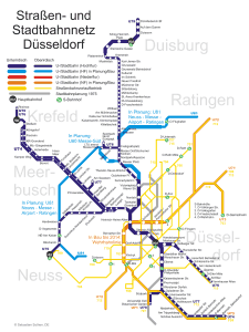
The meter of Düsseldorf or perhaps better said, Düsseldorf urban train, is known locally as “Düsseldorfer Stadtbahn” or simply “Stadtbahn“, and is a transportation system in the city of Düsseldorf, Germany.
This system that mixes metro, modern train and tram, The 4 October 1981, and currently has 11 lines and more 170 stations, covering a total distance of 68.5 kilometres (42.6 miles). Its last expansion was in the year 2022.
Map of urban train and other transport
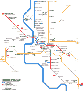
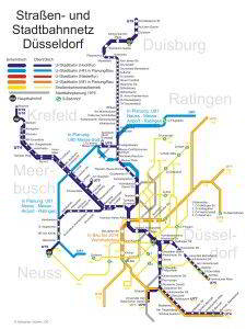
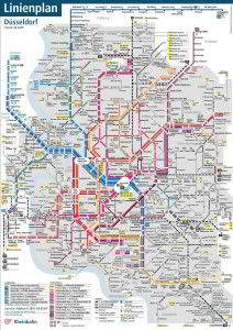
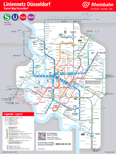
Below we show you the Düsseldorf metro map in various formats. Click on the image to see it larger:
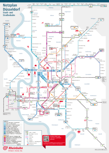
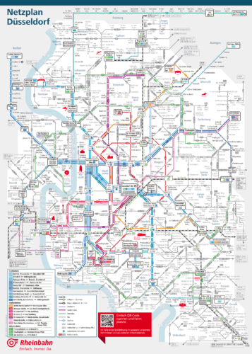
Map 1: Düsseldorf tram and subway map: This map focuses specifically on tram and metro networks (U-Bahn). It would be useful for travelers looking to move mainly within the city using these two means of transportation.. [Download the map in PDF] [Map source].
Map 2: Detailed map of the Düsseldorf metro: This last map exclusively details the metro network (U-Bahn) in Düsseldorf, providing an in-depth view of all available metro lines and stations. It is the most appropriate for those who use the metro as their main mode of transportation within the city. [Download the map in PDF] [Map source].
Map 3: Comprehensive Düsseldorf transit map: This map shows the complete coverage of transport services in Düsseldorf, including regional trains, S-Bahn (urban trains), U-Bahn (metro), trams and buses. It is ideal for understanding all the transportation options available in the city and nearby areas. [Download the map in PDF] [Map source: Sergey Singer].
Official Web site
- For more information, you can visit the official website of the Düsseldorf metro.
- For the website of guided tours of Düsseldorf with monobike visit this website.
Schedules
- Weekdays and Saturdays: 4:30h a 1:30h
- Sundays and holidays: 5:00h a 1:30h
Düsseldorf Metro Fares
Next, A table is presented with the main prices in euros and their equivalent in US dollars (so that tourists have a better idea of the price).
| Type of ticket | Precio (EUR) | Precio (USD) |
|---|---|---|
| One-way ticket (Single ticket) | 3.00 EUR | 3.26 USD |
| day ticket (Day ticket) | 8.00 EUR | 8.70 USD |
| weekly ticket (Weekly ticket) | 28.00 EUR | 30.50 USD |
| Monthly ticket (Monthly ticket) | 91.00 EUR | 99.00 USD |
| Annual ticket (Annual ticket) | 970.00 EUR | 1,054.00 USD |
In addition to standard tickets, the Rheinbahn AG offers various cards and special discounts:
- Small group ticket (4erTicket): This option allows a group of up to five people to travel together with a significant discount. It is ideal for families or groups of friends who plan to explore the city.
- student ticket (SchülerTicket): Students can benefit from reduced fares to facilitate their daily trips to school or university.
- tourist ticket (TouristenTicket): This ticket offers special rates for tourists, including discounts on tickets to attractions and museums in the city.
- Combined ticket (KombiTicket): Some events in Düsseldorf, like concerts or soccer games, include a combined ticket that allows free use of public transport on the day of the event.
- Deutschlandticket: This is a national ticket that allows unlimited travel on public transport throughout Germany for a fixed monthly price, ideal for those who travel frequently.
For more information on fares and ticket options, It is recommended to visit the official website.
Is it a subway or is it an urban train?
at Düsseldorf, The term “metro” It is not used in the same way as in many other cities. Instead, The underground public transport network and part of it above ground is mainly known as U-Bahn, abbreviation for “Untergrundbahn“, which literally translates as “Subway”. Although the U-Bahn It serves a similar function to metro systems in other cities, part of your network can operate above ground, especially on the outskirts of the city.
Confusion sometimes arises because the U-Bahn Düsseldorf is integrated with other transport services, As the Train (suburban trains) and the trams. Besides, some lines of U-Bahn in Düsseldorf they share sections with tram lines, which is part of a system known as Stadtbahn. The term Stadtbahn refers to a hybrid system that combines tram and metro elements, operating both in underground tunnels in the city center and on surface roads in less densely populated areas.
History of the subway
Plans for the construction of the subway in Düsseldorf , They started in the decade of 1960. At that time, the city needed an efficient transportation system to support its growth as a cultural center, financial and economic. The 19 December 1968, the city council approved the construction of the subway, marking the beginning of a project that would change the face of Düsseldorf.
The first phase: 1973-1981
The first important milestone came on 24 March 1973, with the laying of the first stone in Fischerstraße. This initial stage included the construction of tunnels and underground stations., totalizing 6.9 kilometers and twelve stations. In 1973, construction of the northern section began from Heinrich-Heine-Allee. In 1981 the first section of the tunnel was completed.
Inauguration and new Lines: 1981-2000
The 3 October 1981 was inaugurated, with a route from Kennedydamm until Heinrich-Heine-Allee. During the following decades, he Stadtbahn continued to expand. In 1983, The line extended to Oberkasseler Brücke.
In the years 90, projects were started to connect more suburban areas and improve system coverage.
The Wehrhahn-Linie
A highlight in the history of the Düsseldorf metro is the construction of the Wehrhahn-Linie. This project, started in 2007 and finished in 2016, added a new route that crosses the city from east to west, significantly improving connectivity and reducing travel times. The Wehrhahn-Linie It represented a technical advance and also a work of urban art, with stations designed by contemporary artists.
Engineering and construction companies
The development of the Düsseldorf metro involved leading engineers and several construction companies. The Rheinbahn AG, main public transport operator in the city, played a crucial role in the management and execution of these projects. Besides, the collaboration with the Duisburger Verkehrsgesellschaft AG In the operation of line U79, he highlighted the importance of regional cooperation for the success of the system..
History of the Düsseldorf subway map
Since its beginnings, Several designers and engineers have contributed to the development of the Düsseldorf metro map (known as Stadtbahnnetz).
Early designs and developers
The first maps of the Düsseldorf metro were created during the initial planning of the system in the 1990s. 1960. These early designs were essentially technical and were used to plan routes and stations.. The company Rheinbahn AG, main operator of the public transport system in Düsseldorf, played a crucial role in this initial stage.
Evolution over the years 70 y 80
In the decade of 1970, with the beginning of the construction of the subway, a more detailed and accessible map for the public became necessary. In this phase, Engineers and urban planners collaborated closely with graphic designers to create a map that was easy to read and understand. The U79 line, one of the first to be completed, became a model for future map design.
Modernization and digitalization
With the advancement of technology over the years 90 y 2000, Düsseldorf metro maps have also been modernized. The introduction of design software such as LineMap Draw allowed designers to create more accurate and visually appealing maps (attractive at that time, currently they are horrible maps that look like they were made with Paint from Microsoft). This software made it easy to create schematic diagrams that improved clarity and readability, prioritizing simplicity over geographic accuracy.
Contribution of companies and designers
The development of the Düsseldorf metro maps has involved the participation of several independent companies and designers.. Among them, Jörg Siebrands and its software LineMap Draw have been fundamental. This program allowed the creation of scalable and adjustable plans, essential for the large format maps seen at stations and in information brochures (Fuente: Kuhn specialist media).
The current map
The current Düsseldorf metro map reflects decades of refinement and improvement. The collaboration between Rheinbahn AG, graphic designers and engineers has resulted in a map that is both functional and aesthetically more pleasing than the previous one. Stations and routes are clearly marked, and the design uses distinctive colors for each line, making navigation easier for users.
The last Düsseldorf metro station to open is the station Düsseldorf-Bilk. This station is part of the line Wehrhahn (Wehrhahn-Linie) and was completed in 2016. However, Continuous improvements and upgrades culminated in the opening of a new platform for regional train services in March 2022, significantly improving station capacity and connectivity.
This station is an important connection node in Düsseldorf, providing access to several lines of the Stadtbahn, as well as regional train services and the S-Bahn, which makes it a key point for public transportation in the city.
The map of the future
The current official map, although technically it is impeccable, It has a rather complicated design and is very difficult for tourists to understand. Maybe that's why artists like Sergej Singer who are creating their own maps (for me, your map is the best of all), simpler and clearer to improve the official map, although it does not succeed either since it abuses gray colors.
They should understand that subway maps, many times, they are for printing, and what if they saturate the map with unnecessary colors and especially the grays that they put in the background, They cause the printing of ugly maps and waste a lot of unnecessary ink for printing on paper.. Although on the other hand we must understand that the Düsseldorf map is quite a challenge due to its very high complexity., since there are many lines and little space available.
Additional data
The Düsseldorf metro is also a way to reach most of the city's most emblematic places. They stand out among them:
- Königsallee (stop: Steinstraße/Königsallee, line U78/U79): Iconic shopping street with luxury shops, boutiques and a beautiful central canal.
- Altstadt (stop: Heinrich-Heine-Allee, lines U70/U74/U75/U76/U77/U78/U79): Known as “The longest bar in the world”, famous for its lively nightlife and breweries.
- Rheinturm (stop: Landtag/Kniebrücke, line U70/U74/U75/U76/U77): Telecommunications tower with a viewing platform offering panoramic views of the city and the Rhine River.
- MedienHafen (stop: Speditionstraße, line U71/U72/U73/U83): Revitalized area with modern architecture, restaurants and bars on the shores of the port.
- Schloss Benrath (stop: Schloss Benrath, line U71/U83): Baroque palace with impressive gardens and museums dedicated to natural history and art.
- Kunstsammlung Nordrhein-Westfalen (stop: Heinrich-Heine-Allee, lines U70/U74/U75/U76/U77/U78/U79): Museum of modern and contemporary art with masterpieces from the 20th and 21st centuries.
- Hofgarten (stop: Tonhalle/Ehrenhof, line U70/U74/U75/U76/U77): Extensive urban park, ideal for quiet walks, picnics and outdoor activities.
- Kaiserswerth (stop: Klemensplatz, line U79): Historic neighborhood with ruins of the Kaiserpfalz and picturesque old houses on the banks of the Rhine.
Old Düsseldorf subway maps
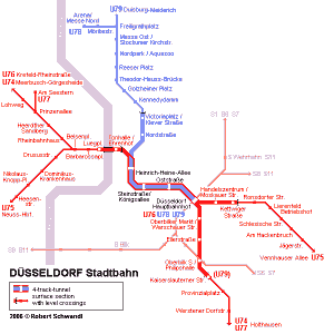
In historical mode, We are hanging the maps from previous years as a curiosity. In these cases they are from the year 2014 and previous years:
