The call “metro” of Auckland is officially called City Rail Link (CRL) and is the largest transport project in New Zealand's history, located in Auckland, The largest city in the country.
Although it's not a traditional subway system, the CRL is an underground urban train that will significantly improve public transport connectivity in the city.
It is expected that the City Rail Link Transform the existing rail system by creating an underground connection that will provide easier access to various parts of Auckland. The project, Once Finished, It will feature 3.45 kilometres (2.14 miles) tunnels and new underground stations.
At the moment (2024), the CRL is at an advanced stage of construction. Tunnels and stations are in the process of being completed.
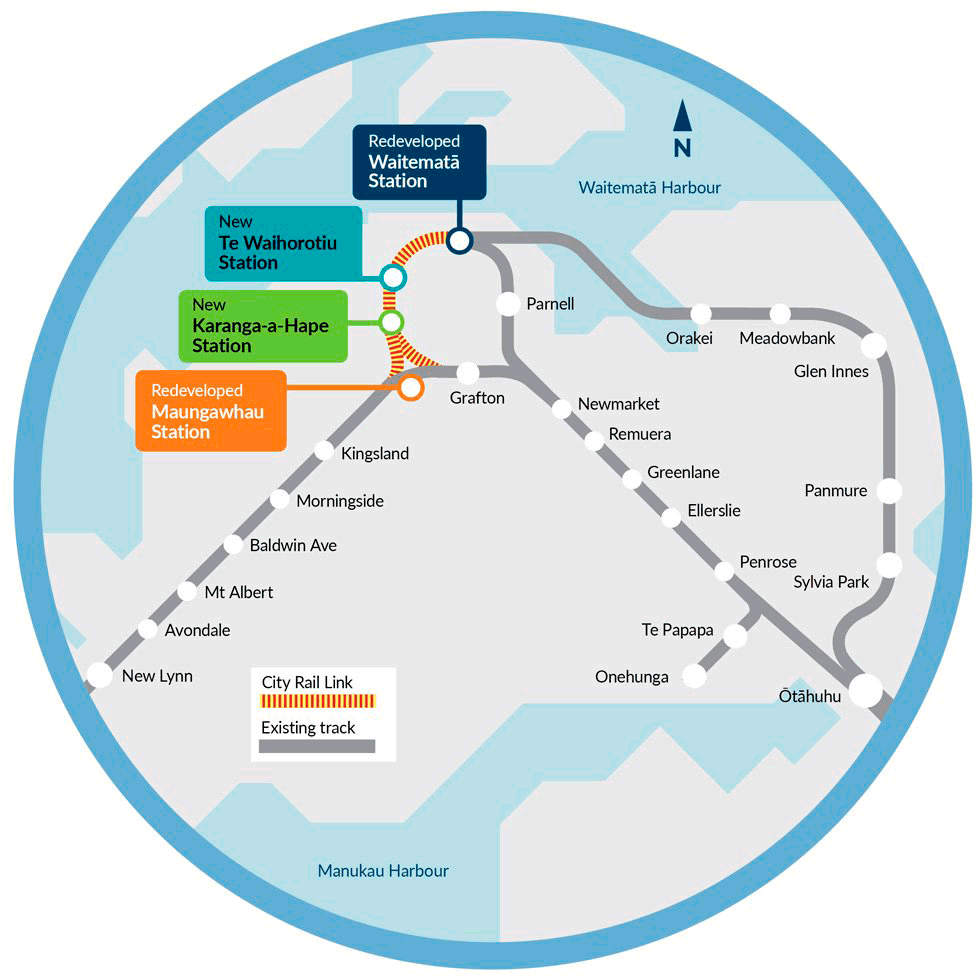
Key stations like Waitematā (Britomart), Karanga-a-Hape y Maungawhau (Mount Eden) are being prepared for their planned opening in early September. 2026. The tunnel has been completed and system installation work is underway, Signage & Final Testing.
subway map
Here's a look at the future map of City Rail Link of Auckland, click on the image to see it larger:
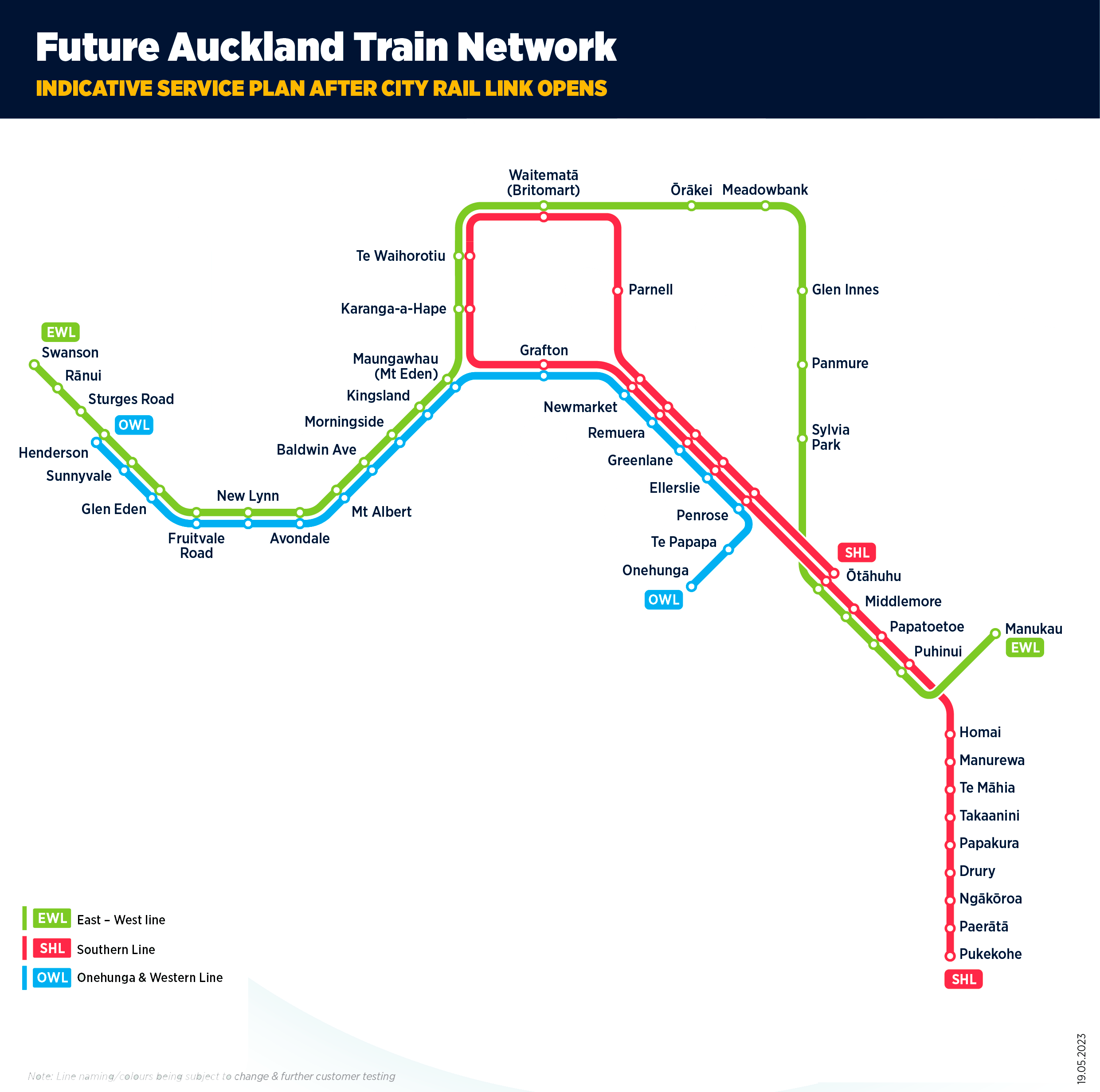
Simplified Map:
City Rail Link timetable
- Monday to Friday: 5:00 AM – 11:00 PM
- Saturdays: 6:00 AM – 11:00 PM
- Sundays and holidays: 7:00 AM – 10:00 PM
Tarifas del City Rail Link
- Single ticket price in local currency (NZD): 3.50 NZD
- Single ticket price in U.S. dollars (USD): about 2.30 USD
Official website of the “metro” of Auckland
- This is the official website: City Rail Link (CRL) – Auckland.
- Website where they have a Huge list of interesting attractions in Auckland.
History of Auckland City Rail Link
The idea of City Rail Link it has been present in Auckland's strategic plans for decades. In the decade of 1920, An underground diversion was first proposed in Morningside, but it was rejected in 1930.
During the years 1940 y 1950, Several attempts were made to electrify the railway system and build underground tunnels, but none came to fruition due to a preference for a highway system similar to that of Los Angeles.
In the decade of 1970, the Mayor of Auckland, Sir Dove-Myer Robinson, He proposed a high-speed train system that was also not realized.
It was until the year 2004 that Auckland City Council prepared preliminary plans for an underground railway connecting the Britomart Transport Centre with the western line in the vicinity of the station Mount Eden.
Construction of the CRL officially began in December 2015. The project has faced numerous challenges, including delays and cost increases due to the COVID-19 pandemic and disruption to global supply chains.
During the project's excavations, Significant historical artifacts were discovered, as parts of the old boardwalk Customs St and remains of the dock Queen St, dating back to the mid-nineteenth century. These findings have been documented and preserved, Adding a historical dimension to the project.
The main infrastructure is expected to be completed by November 2025, and the system will be operational in early 2026.
Auckland Subway Map History
The design of the map City Rail Link It has been a collaboration between several entities to ensure its functionality and aesthetics.
The CRL's final station and route designs were developed by a consortium known as Link Alliance, which includes design and construction companies such as Vinci Construction Grands Projects, Downer NZ, y WSP New Zealand.
This consortium was responsible for the physical construction of the project and also for the information on the maps, is clear and accessible to all.
Additional data
- The CRL includes new stations in Aotea, Karangahape y Mount Eden, that will significantly improve access to public transportation in these areas.
- CRL project expected to increase capacity of Auckland's rail system, allowing more trains to run more frequently.
- Station Aotea will be the largest train station in New Zealand, located in the heart of Auckland's central business district.
- The most important tourist places in Auckland are accessible by metro, These are the main places:
- Sky Tower (Season Te Waihorotiu (Aotea), CRL line): An iconic viewpoint offering panoramic views of Auckland.
- Auckland Art Gallery (Season Te Waihorotiu (Aotea), CRL line): New Zealand's most extensive art gallery with national and international collections.
- Auckland War Memorial Museum (Season Waitematā (Britomart), CRL line): Auckland Region War Memorial & Museum.
- Viaduct Harbour (Season Waitematā (Britomart), CRL line): Important area for its restaurants, Bars & Harbour Views.
- Mount Eden (Season Maungawhau (Mount Eden), CRL line): A dormant volcano with a park and panoramic views of the city.
- Aotea Square (Season Te Waihorotiu (Aotea), CRL line): Large public space and venue for various events and shows.
- Karangahape Road (Season Karanga-a-Hape, CRL line): Famous street known for its intense nightlife and very peculiar shops.
- Queen Street (Season Waitematā (Britomart), CRL line): The main commercial artery of downtown Auckland.