The urban train Cologne officially known as “Kölner Stadtbahn”, is an underground and surface transport system operating in Köln, Germany. It is sometimes called “Cologne metro” but it is not really considered as an urban metro, but rather as part of the country's rail system.
It was inaugurated on 11 October 1968, and has 12 lines operating along 236 stations (42 they are underground), distributed over a path of approximately 198.5 kilometres (123,34 miles).
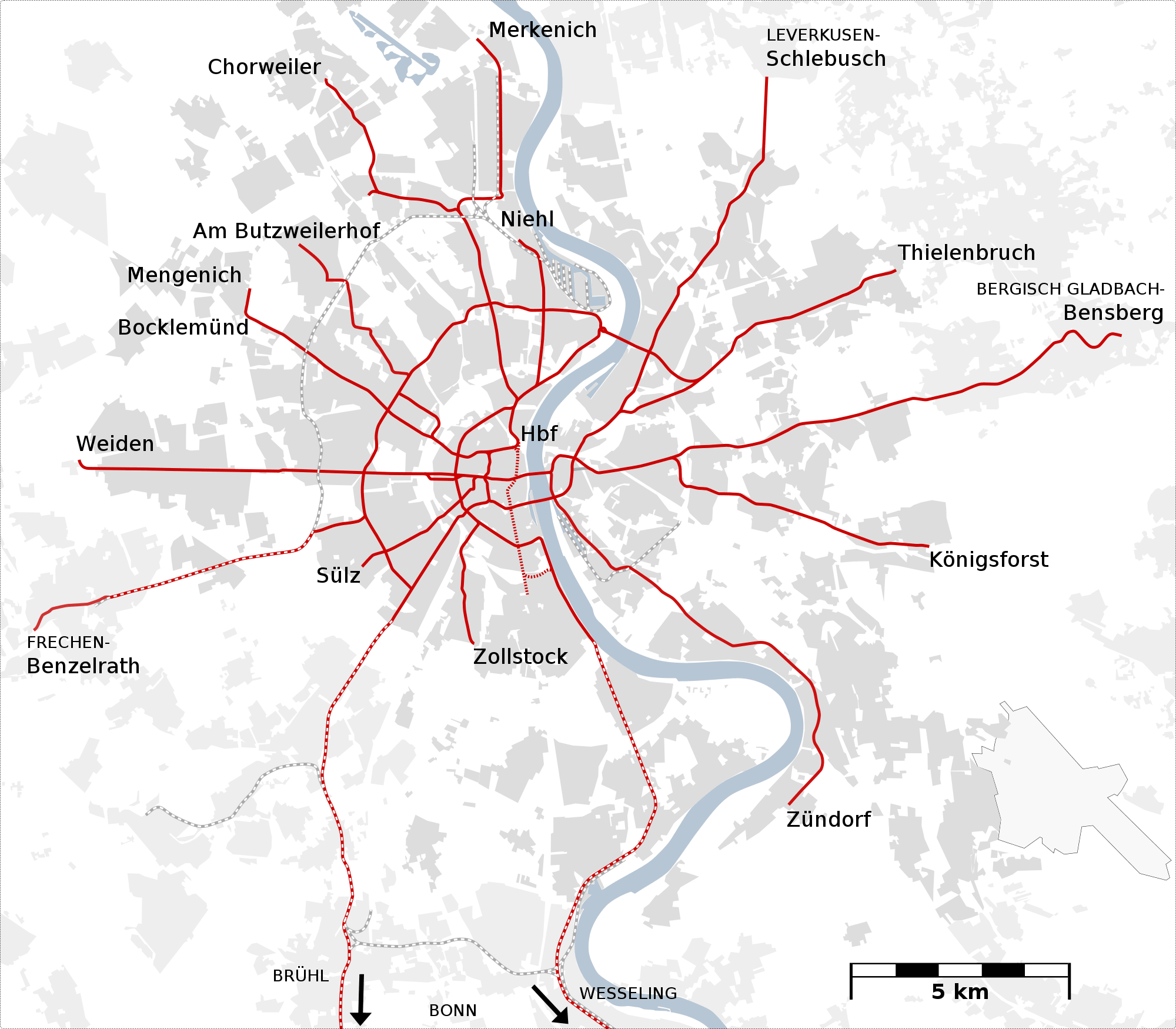
This transport network covers both the urban center and peripheral areas and connects with various cities in the Cologne-Bonn region., like Bergisch Gladbach, Bonn and Frechen.
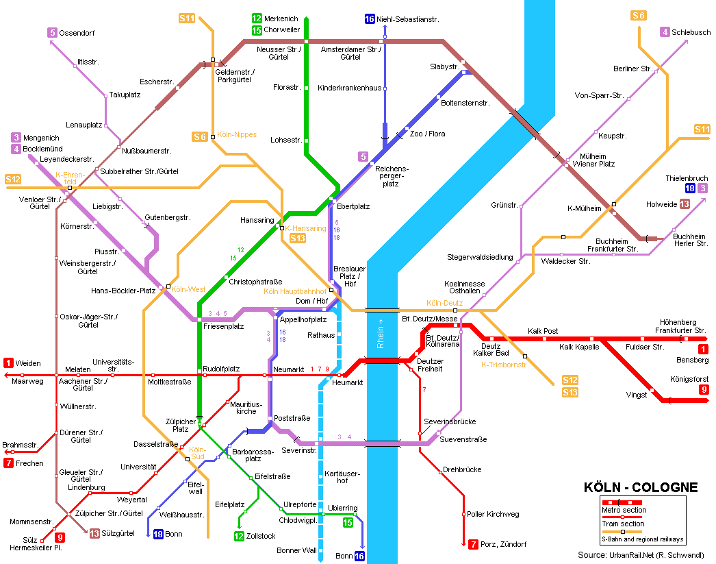
subway map
Here's the Cologne city train map:

Official Web site
- This is the official website of the Cologne urban train.
- This is the website where they are all Cologne attractions, with places you can't even imagine.
Urban train schedules Cologne
The Cologne Urban Train operates with the following schedules:
- Weekdays and Saturdays: of 4:30h until 0:30h.
- Sundays and holidays: of 6:30h until 0:30h.
Rates
The system offers the following rate options:
- The urban train system Cologne (Germany), known as Stadtbahn, offers several ticket options:
- One-way ticket: Available for short or longer trips, depending on the category. The basic single ticket costs 3,10 EUR (~3,40 USD) and is valid for 90 minutes in the area 1. First class ticket adds a small surcharge.
- Day Ticket: With a cost of 8,60 EUR (~9,43 USD), offers unlimited trips for one day on all lines, including buses, trams and subways. This ticket is ideal for tourists or those who plan to move a lot during the day..
- In addition to these options, There are special tickets like AzubiTicket for young people in training, group discounts, and the HandyTicket with a reduction of 3% when purchased through the mobile app.
History of the urban train Cologne
The history of the “metro” of Cologne (Köln) began in the decade of 1960. The city faced increasing traffic, so he decided to build an underground train system. The first section was inaugurated on 11 October 1968, Connecting Friesenplatz y Dom/Hauptbahnhof.
In 1974, was founded Stadtbahngesellschaft Rhein-Sieg GmbH, in charge of coordinating metro network projects, including the integration of Rheinuferbahn. For 1978, the line 16 began operating between Köln-Mülheim y Bonn-Bad Godesberg.
The first tunnel on the right bank of the Rhine was completed in phases between 1976 y 1983. This tunnel included key stations such as Fuldaer Straße, Kalk y Deutz/Messe. In 1983, the station Kalk Kapelle was integrated into the system, allowing a seamless crossing with the line of Königsforst.
The system continued to expand. In the years 80, new lines and stations were added. In 1985, the line was completed 18, connecting with the Vorgebirgsbahn. Besides, Major modernizations and expansions were carried out in the following decades.
In 2009, a significant incident occurred: the collapse of Historisches Archiv der Stadt Köln during the construction of the Nord-Süd Stadtbahn, causing the death of two people (Cologne Deutz).
At the moment, the system continues to expand. The third phase of the Nord-Süd Stadtbahn includes the extension of the line up to Arnoldshöhe, with four new stations planned.
History of the urban train map Cologne
The history of the Cologne metro map (Köln) It is marked by various phases of development and various contributions from designers and companies.
Twentieth century
The company Kölner Verkehrs-Betriebe (KVB) has been primarily responsible for the operation and design of the metro maps since their creation. In 1968, When the first line of the Stadtbahn, the first subway map was presented. This initial map, although rudimentary, provided an essential guide for users of the new underground routes. The map was presented as a simple linear diagram, aligning the main tram and train lines.
In the decade of 1970, with the expansion of the network and the introduction of new lines and stations, increased network complexity. For this reason, KVB hired several graphic designers to modernize and clarify the map. One of the key designers during this era was Jürgen Stoll, who introduced a cleaner and more readable design, influenced by the subway maps of other large cities such as that of the London subway and the paris metro.
During the years 80 y 90, the evolution of the Cologne urban train map continued with the collaboration of the design company SSB (Stadtbahngesellschaft Rhein-Sieg GmbH), that helped integrate new network expansions, like the lines that connect to Bonn. The unification of rates and the creation of the Verkehrsverbund Rhein-Sieg (VRS) in 1987 They also influenced the redesign of the map, since it needed to reflect a more interconnected and accessible transportation network.
One of the main drivers of its design was Wilhelm Deitermann, a transportation engineer who worked on system planning. Together with your team, was responsible for the urban rail map transition of Cologne towards a more simplified and stylized graphic design in the years 80.
XXI century
In 2004, the airport station Köln/Bonn Flughafen was added to the map, requiring another significant update. This update was carried out by a team of designers led by Martin Stein, who worked to improve the accessibility and aesthetics of the map, using more distinctive colors for each line and clearer symbols for important connections.
The incident in 2009, when the collapsed Historisches Archiv der Stadt Köln, led to a complete revision of the map to include the new Nord-Süd Stadtbahn, whose second phase was completed in 2015. This update work was managed by the VRS company in collaboration with KVB, ensuring that the new design met modern standards and user needs.
The third phase of the Nord-Süd Stadtbahn and other planned expansions are underway, which will lead to future map revisions. The KVB company and contract designers continue to adapt the design to improve the clarity and functionality of the map, ensuring it adequately reflects Cologne's growing transport network.
Additional data
The urban train system Cologne connects passengers with some of the most emblematic and cultural places in the city:
- Colonia's cathedral (Dom): through the station Dom/Hauptbahnhof, This Gothic masterpiece is an essential stop, where visitors can admire the splendor of the structure and the pretty plaza around it.
- Museo Ludwig: Located near the same station, The Ludwig Museum is famous for housing an impressive collection of modern and contemporary art, with works by Picasso, Warhol and Lichtenstein.
- Historic Center of Cologne (Altstadt): from the station Heumarkt, passengers can explore the old town, full of shops, Restaurants and traditional architecture that reflect the city's rich history.
- RheinEnergieStadion: Sports fans can easily reach the stadium via the above-ground station Stadion, football team headquarters 1. FC Köln.
- Cologne Zoo: Zoo/Flora station offers direct access to the zoo and Botanical Gardens, providing a day full of activities for families and nature lovers.
Old Cologne metro maps
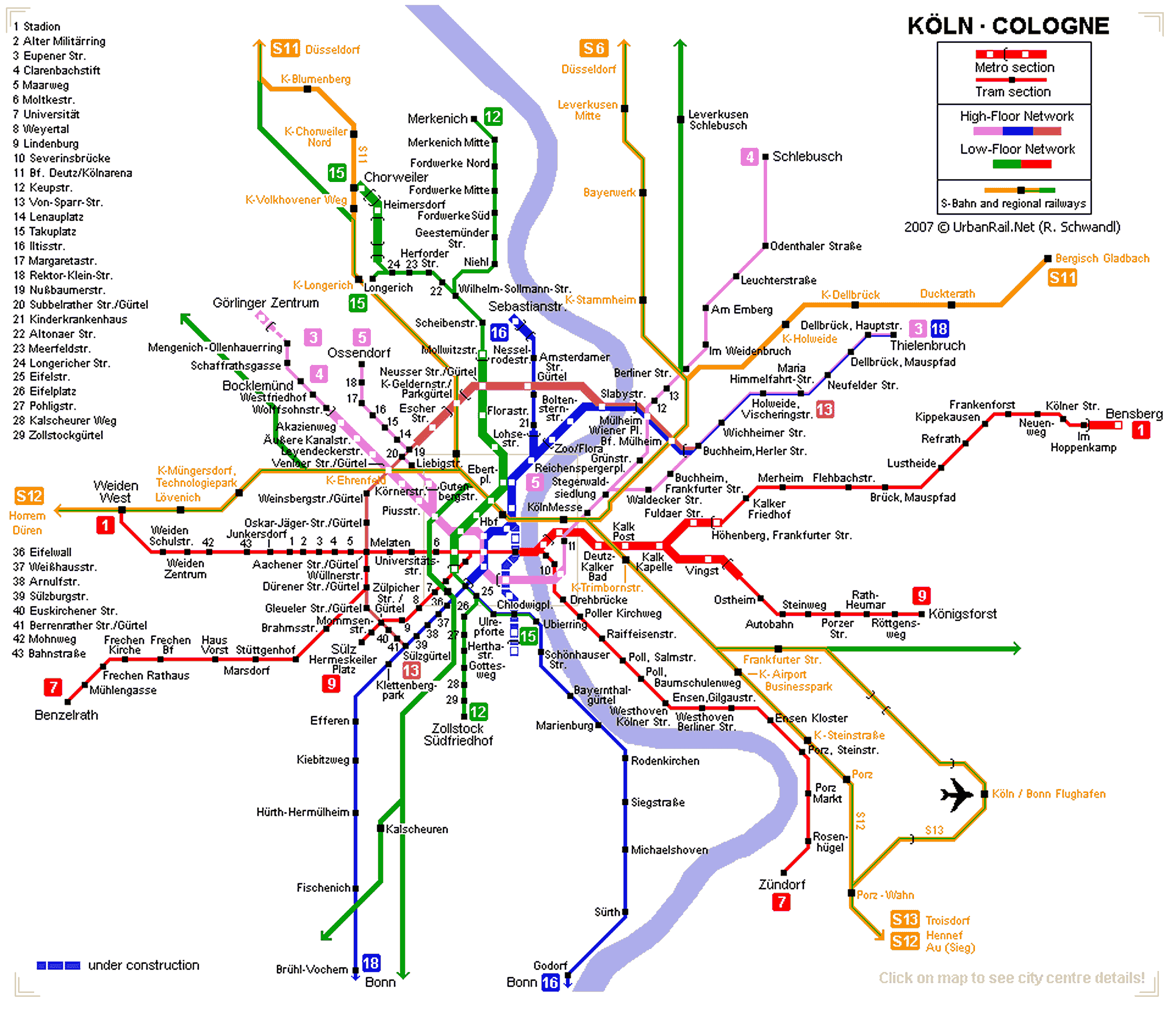
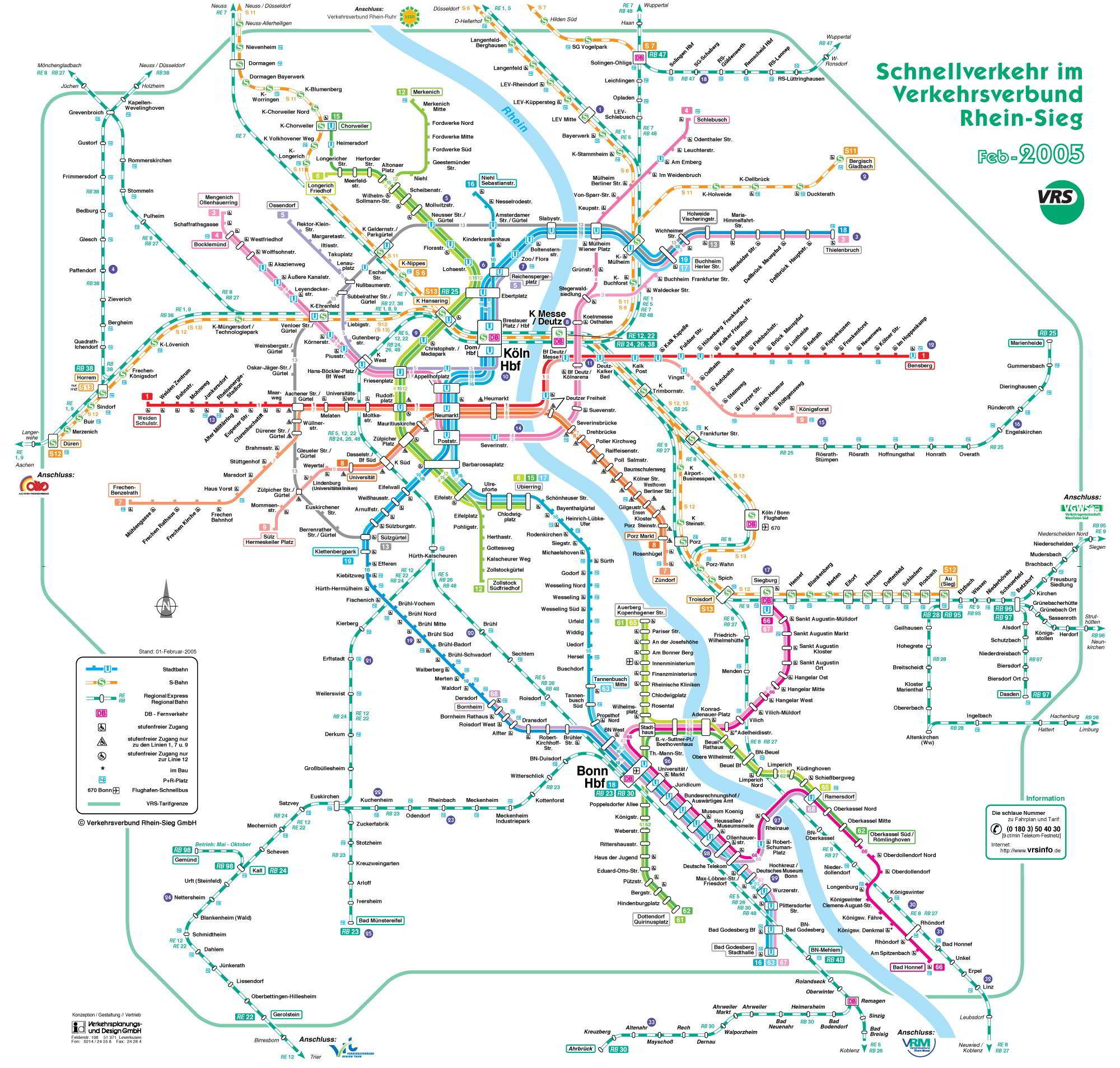
In a historical way we are hanging here the old subway maps, specifically these are from the year 2014 and previous years: