Dublin MetroLink is a high-capacity, high-frequency public transport infrastructure project, If everything goes well it will be inaugurated within the year 2030.
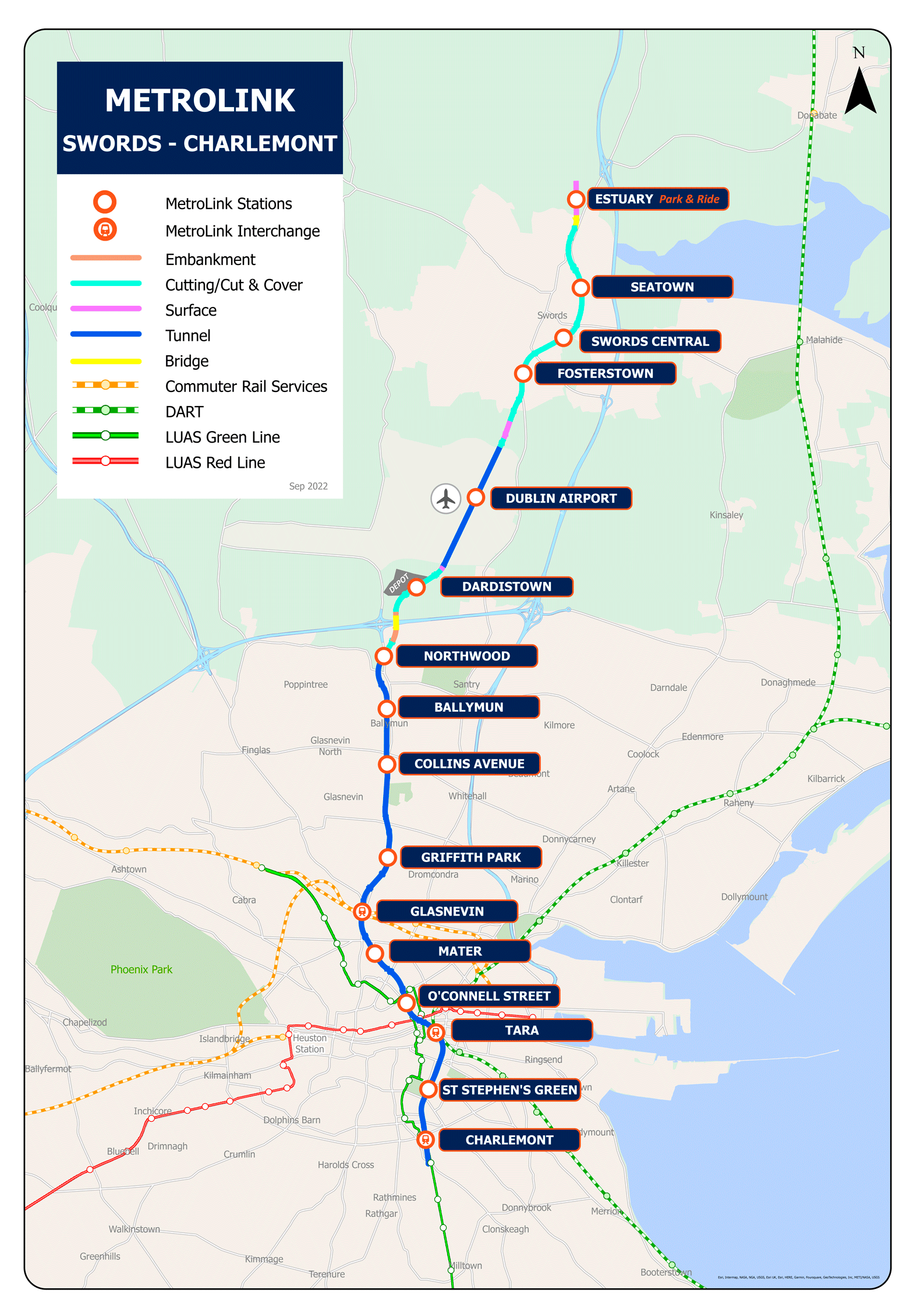
This system will unite Swords, to the north of the city, con Charlemont, al on, through a journey of approximately 19 kilometres, mostly underground. It will have 16 stations that will link key points such as Dublin Airport, the University of Dublin and the Trinity College.
Future subway map from Dublin
Future subway map, which is still under construction until the year 2030:
Schedules
MetroLink will operate with trains every three minutes during peak hours, increasing to one train each 90 seconds to the year 2060. Travel time between Swords and Dublin city center will be approximately 25 minutes.
Rates
Rates are not yet fully defined, but they are expected to be competitive and accessible, integrated with other public transport services in Dublin such as DART and Luas.
Official Web site
- Dublin Metro official website: MetroLink.ie.
- Website with all the Dublin attractions and shows.
History of the subway
Dublin's MetroLink project has been in development for more than two decades. The first significant proposal was the MetroNorth, part of the transportation plan “Transport 21” in 2005.
The MetroNorth was to connect Swords with St. Stephen's Green, passing through Dublin Airport. However, Financial problems and shifting government priorities caused delays and modifications.
In 2018, the National Transport Authority (NTA) submitted a revised proposal under the name MetroLink. This new plan included 16 stations and a mostly underground route from Swords to Charlemont. To improve integration, Interchanges with other public transport lines such as DART and Luas were designed at key stations such as Tara Street and Glasnevin.
The MetroLink project is divided into several phases. In December 2019, test drilling began, and in March 2020, the firm SNC-Lavalin was hired as operations advisor. Despite delays caused by the COVID-19 pandemic, Research work in the field resumed in November 2020.
In 2022, the railway order was approved, allowing progress with planning and construction. Atkins, part of the SNC-Lavalin group, took care of the detailed designs. Construction is scheduled to begin in 2025, with an expected opening in the early 2000s 2030.
Dublin MetroLink Map History
The design of the MetroLink map, although it has been short because the metro has not yet been released, It has been a collaborative effort between multiple entities and experts.
Initial planning and reviews have been managed by the National Transport Authority and Transport Infrastructure Ireland (TII). Engineers and consultants from SNC-Lavalin and Atkins have played crucial roles in developing the detailed layout and station designs..
The map design has gone through several iterations, adapting to project changes and public feedback. Each version has sought to improve clarity and functionality, ensuring an accurate and useful representation of the proposed system. Besides, The inclusion of intermodal stations and integration with other transportation services have been central aspects of the design, highlighting the connection with the DART, Luas and Dublin Airport.