The Stockholm metro, officially called Stockholms tunnelbana, is the metro system that operates in the city of Stockholm, Sweden. Inaugurated on 1 October 1950, this urban transport system is one of the most emblematic in Europe.
The metro has 7 lines spanning a total length of 110 kilometres (68.35 miles) and offers service to 100 stations in and around the city.
Stockholm metro map
Below we show you the Stockholm metro map, To see the larger image click on:
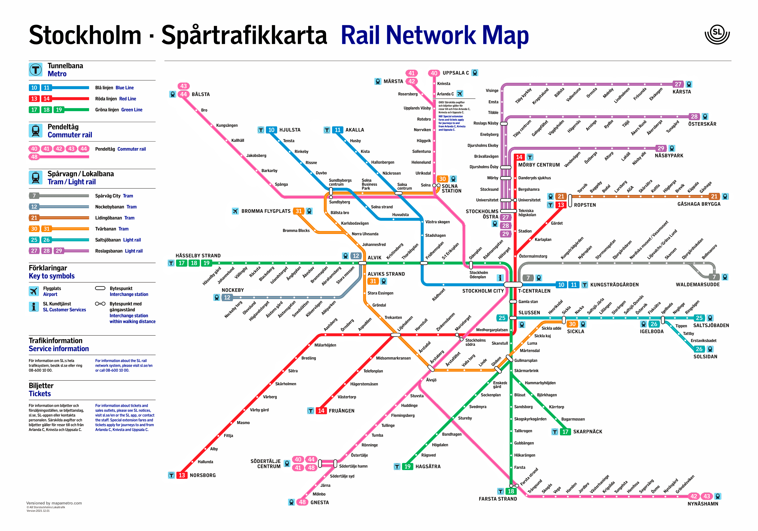
The same map of Stockholm in PDF format.
Schedules
Stockholm Metro operates daily with the following schedule:
- Every day: 5:00 h a 1:00 h.
Stockholm Metro Fares
Next, Current Stockholm Metro fares presented. Prices are shown in Swedish kronor (SEK) with its approximate equivalent in U.S. dollars (USD) incidentally.
| Type of ticket | Precio (SEK) | Precio (USD) |
|---|---|---|
| One-trip ticket | 37 | (3.50) |
| Bill of 24 hours | 155 | (14.60) |
| Bill of 72 hours | 310 | (29.20) |
| Bill of 7 days | 405 | (38.20) |
| Monthly ticket | 950 | (89.60) |
| Annual ticket | 10,590 | (998.00) |
Discounts: The children (7-19 years), The Elderly (65+) and students have a 50% discount on most tickets.
Tickets can be purchased from vending machines, online, in authorized stores, and contactless payment with Visa cards is accepted, Mastercard or American Express.
This table clearly and concisely summarizes the fare options available to Stockholm Metro users., ensuring that both residents and visitors can plan their trips effectively.
Official Web site
- The official website of the metro is: sl.se
- The website with all shows and attractions in Stockholm.
History of the subway
In 1941, decided to build a metro due to the growing problem of congestion on the streets of Stockholm, Where Cars, Buses and trams competed for the limited space..
Initial Phase and First Lines (1950-1960) The first section of the metro was inaugurated on 1 October 1950, Connecting Slussen con Hökarängen. They converted this line from a tram operation to a subway operation. Later, in 1951, They opened a second line from Slussen until Stureby. In 1952, added another section from Hötorget To the western suburbs. Local Businesses, with the support of Swedish engineers and urban planners, They built these initial lines.
Expansion and Development (1960-1970) During the years 60, The east and west parts were connected via the central station, -Centralen, forming the Green Line. The Red Line opened in 1964, extending from T-Centralen towards Liljeholmen, ending in Fruängen y Örnsberg. This expansion was managed by several Swedish construction companies and overseen by the Stockholm County Council.
Modern Development & Blue Line (1970-1990) The Blue Line, the last one to be added, was inaugurated in 1975, with two lines extending northwest from the city center. This line is characterized by its construction that is almost entirely underground, due to the stricter construction requirements that arose over time. Skarpnäck station, The Last Major Addition, was inaugurated in 1994.
Recent and Future Expansions (1990-Gift) Recently, have been planned and are under development 18 Additional Stations. In 2022, The first railway contract was signed for the extension of a new metro line, A significant project that marks the first expansion in approximately 30 years. This project includes the construction of a double-track section between Akalla y Barkarby, with the participation of the company Strukton Rail.
History of the Brussels metro map
The Stockholm metro map has gone through several transformations since its inception:
Initial Design and Evolution (1950-1970) The first subway map, Designed in 1950, It was quite simple and represented the few opening lines. As the subway expanded over the years 60 y 70, The map was updated to include the new lines and stations. Local artists and graphic artists designed the first maps under the supervision of Storstockholms Lokaltrafik (SL), the Stockholm Transport Authority.
Modernization and Current Design (1980-Gift) With the inauguration of the Blue Line in 1975, A more significant revision of the map was needed. In the decade of 1980, Teams of graphic designers and urban planners were responsible for the design of the map, introducing a more streamlined and functional approach, Similar to subway maps of large cities such as London y New York.
Participation of Modern Companies and Technologies In recent decades, Companies such as Strukton Rail and other contractors have been involved in updating not only the physical infrastructures but also the digital maps and signage of the metro. These upgrades include the use of modern information technologies and digital design to make it easier for users to navigate the metro system.
Additional data
The Stockholm metro is not only a means of transportation, but also an underground art gallery. Many of its stations are known for their stunning artistic decorations, turning them into tourist destinations in their own right. Among the most famous stations are T-Centralen, Kungsträdgården y Solna Centrum.
The most important tourist attractions in Stockholm, and that can be accessed by metro are the following:
- Gamla Stan (Gamla Stan, Green Line): Stockholm's Old Town, Packed with cobblestone streets and historic buildings.
- Royal Palace (Gamla Stan, Green Line): Official residence of the Swedish Royal Family, Open for visits.
- Vasa Museum (Kungsträdgården, Blue line): Naval Museum Exhibiting the Vasa Warship, Sunk in 1628.
- Skansen (Karlaplan, Red Line): Open-air museum and zoo with historic houses and buildings.
- Abba Museum (Karlaplan, Red Line): Celebrating the famous Swedish band, Offer an interactive experience.
- Djurgården (Karlaplan, Red Line): Island that is home to several museums, Parks & Amusement Park Gröna Lund.
- Fotografiska (Slussen, Green Line): Museum of Contemporary Photography, with temporary exhibitions and a café overlooking the sea.