The amsterdam metro (officially “Amsterdamse Metro“) The 16 October 1977, This system serves Amsterdam and its surroundings, extending to municipalities such as Diemen and Ouder-Amstel.
Managed by the municipal company GVB, The metro currently has five active lines, 52 stations and a total length of 43 kilometres (26.7 miles).
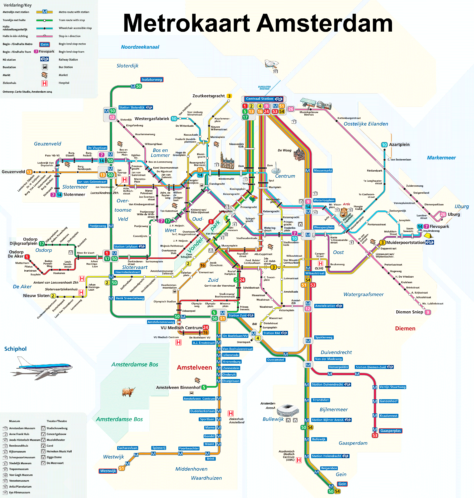
subway map
Below we show you the Amsterdam metro map. Click on the image to see it larger:

If you wish, you can download the same Amsterdam metro map in PDF format.
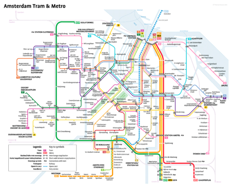
We have this other retouched map from Wikipedia:

Schedules
The Amsterdam Metro operates every day from 6:00 a 0:30.
Amsterdam Metro Fares
Next, Amsterdam metro fares are presented in Euros and their approximate equivalent in US dollars:
| Type of ticket | Price in EUR | Rate in USD (approximate) |
|---|---|---|
| One-way ticket (1 hour) | 3.20 EUR | 3.52 USD |
| Bill of 1 day | 8.50 EUR | 9.35 USD |
| Bill of 2 days | 13.50 EUR | 14.85 USD |
| Bill of 3 days | 19.00 EUR | 20.90 USD |
| Bill of 4 days | 24.50 EUR | 26.95 USD |
| Bill of 5 days | 29.50 EUR | 32.45 USD |
| Bill of 6 days | 33.50 EUR | 36.85 USD |
| Bill of 7 days | 37.00 EUR | 40.70 USD |
Multi-day tickets and the card are also available. OV-chipkaart, which allows unlimited trips within its validity period. Cards can be purchased at ticket machines or online.
Official Web site
- Official website of the Amsterdam Metro: CFP.
- Website with all the Amsterdam attractions and shows.
History of the subway

The development of the Amsterdam metro began in the years 60. In 1963, was formed Bureau Stadsspoor to evaluate the need for a new railway system. This body published five reports and presented a final plan in 1966 which proposed four metro lines. Initial planning included one North-South line and two East-West lines.
In 1968, The municipal council approved the plans and the necessary budget was allocated. Construction of the first lines began in August 1970 and Weesperplein. However, Necessary demolitions in the city center sparked protests at Nieuwmarkt in 1975, which led to the cancellation of many projected lines. Only the construction of the Eastern line continued.
The first line, la Oostlijn, The 16 October 1977. This line connected the center with the eastern and southeastern districts of Amsterdam, como Bijlmermeer y Amstel.
In the years 90, new lines were inaugurated. In 1990, the line was opened 51, also known as Amstelveenlijn, which combined metro and rapid tram services. La Beltline, line 50, was inaugurated in 1997, providing a circular connection through the city.
The line Noord/Zuidlijn, line 52, It was a significant project.. Its construction began in 2003 and was completed in 2018. This line connects the north and south of the city, crossing the IJ river through a tunnel.
History of the Amsterdam Metro Map
In the decade of 1970, GVB engineers and designers (the municipal transportation company Gemeente Vervoerbedrijf), created the first detailed maps when the Oostlijn line opened in 1977.
In the years 90, the expansion of the system with new lines, like the Ringlijn (line 50) and the Amstelveenlijn (line 51), required significant updates to the map layout. During this time, The maps began to show more details and connections.
The arrival of the line Noord/Zuidlijn (line 52) in 2018, an important project that crossed the IJ River, marked a milestone in the evolution of the map. This project, which lasted from 2003 until 2018, needed a clear representation due to the importance of its connections and its impact on urban traffic.
Designers such as Jaap Knevel and Erik Hammink have contributed significantly to the modernization and stylization of the Amsterdam metro map.. Hammink, For example, has used circular shapes to represent Amsterdam's canals effectively in his unofficial designs, while Knevel has opted for contrasting colors to improve readability and reflect the city's progressive values..
Additional data
The Amsterdam metro is essential for transportation in the city, especially in areas like Bijlmer, Amstelveen y Diemen. The M52 line is known for its stops at important tourist spots such as Rokin and Europaplein. Besides, all stations are equipped with wheelchair access and spacious check-in ports.
These are the most visited tourist places that can be accessed with the metro:
- Museo Van Gogh (parade Vijzelgracht, line 52): It houses the largest collection of Van Gogh's works in the world.. Includes paintings, drawings and letters.
- Rijksmuseum (parade Vijzelgracht, line 52): This national museum exhibits Dutch art and history, highlighting masterpieces such as “The night watch” the Rembrandt.
- Anne Frank House (Parada Central Station, lines 51, 53, 54): Museum in the hiding place where Anne Frank wrote her diary during World War II.
- Heineken Experience (parade Vijzelgracht, line 52): Interactive tour of the former Heineken brewery, including tastings and multimedia activities.
- Plaza Dam (parada Rokin, line 52): Amsterdam historic center, home of the Royal Palace and the Nieuwe Kerk, surrounded by shops and cafes.
- ARTIST Zoo (stop Waterlooplein, line 51, 53, 54): Founded in 1838, It is the oldest zoo in the Netherlands, with a wide variety of animals and botanical gardens.
- Vondelpark (parade Leidseplein, line 52): The largest and most famous park in Amsterdam, ideal for walks, picnics and outdoor activities.