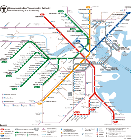
The Boston Subway, officially known as the Massachusetts Bay Transportation Authority (MBTA), It is one of the oldest and most extensive public transportation systems in the United States. Located in Boston, Massachusetts, This metro system began operations on 1 September 1897.
At the moment, The MBTA has three main lines that cover a total length of 109.6 kilometres (68.1 miles) and serve 153 stations. It is crucial infrastructure for daily mobility in and around Boston., providing a fast and efficient means of transportation.
Here's the boston subway map, click on map to enlarge:

Schedules
- Weekdays and Saturdays: 5:00 AM a 1:00 AM
- Sundays and holidays: 6:00 AM a 12:00 AM (midnight)
Rates
These are the prices of Boston subway tickets:
| Rate Type | Precio |
|---|---|
| One-way ticket | $2.40 – $2.90 USD |
| Daily Pass (1-Day LinkPass) | $11.00 USD |
| Monthly pass (Monthly LinkPass) | $90.00 USD |
| Students | Reduced Rates |
| Seniors/Disability | Reduced Rates |
Official Web site
- This is the official website of the Boston Metro: MBTA.com
- This is the website with all tourist attractions and Boston shows. You can also buy tickets with good discounts..
History of the Boston Subway (MBTA)
The Boston Subway, known as MBTA (Massachusetts Bay Transportation Authority), It has a rich and complex history dating back to the late 19th century, when North America's first underground subway system opened.
Beginnings and first expansions (1890s – 1920s)
In response to increasing traffic and congestion on Boston streets, The Rapid Transit Commission was formed in 1891. The commission recommended construction of an underground streetcar tunnel under Tremont Street and four elevated rail lines.. The 1 September 1897 the first section of the metro was inaugurated, known as the Tremont Street Subway, which is still in use today. This tunnel connected the Park Street stations, Boylston y Government Center.
In 1901, was inaugurated Main Line Elevated, the precursor of the Orange Line, as a rapid transit line that used the Tremont Street tunnel downtown. Shortly after, in 1904, they opened the East Boston Tunnel, that connected downtown Boston with East Boston under Boston Harbor, and they converted it for rapid transit in 1924.
Consolidation and modernization (1930s – 1950s)
During the decades of 1930 y 1940, Boston underwent a significant modernization of its streetcar and elevated line system.
The Boston Elevated Railway Company (BERy), name changed, and carried out several expansion and consolidation projects, including the opening of the Washington Street Tunnel in 1908 and the extension of the Cambridge tunnel in 1912, connecting downtown Boston to Harvard Square in Cambridge.
Creation of the MBTA and major projects (1960s – 1980s)
In 1964, the MBTA was created, unifying various transportation entities under a single management structure. This was a turning point for the metro system, which became part of broader regional planning. During the decades of 1970 y 1980, The Southwest Corridor Project was carried out, which realigned and improved the Orange Line, integrating the development of green spaces and recreational areas, demonstrating a commitment to holistic urban planning.
Modernization and recent challenges (1990s – gift)
In 1987, relocated the Orange Line from the Washington Street elevated tracks to a new tunnel, which improved efficiency and reduced travel times. In the XXI century, significant investments have been made in new train cars, station renovations and accessibility improvements. These efforts underscore the MBTA's continued importance to Boston's transportation infrastructure..
For more details on the history of the MBTA, you can visit the following sources:
Boston Subway Map History

The Evolution of the Boston Subway Map, known as MBTA (Massachusetts Bay Transportation Authority), reflects the rich history and changing needs of the city and its inhabitants.
Early maps and the BERy era
The first efforts to map Boston's transit system began with the Boston Elevated Railway Company (BERy), which operated since the end of the 19th century. In these first days, The maps were simple and focused on tram and elevated train routes. In 1947, when the Metropolitan Transit Authority (MTA), maps began to represent a more consolidated network of transit services, spanning fourteen cities and towns in the Boston area.
Introduction of the “Spider Map”
In 1964, with the creation of the MBTA, the first Boston subway map dedicated exclusively to rapid transit was introduced, known as the “Spider Map” o Spider Map. This was designed by the firm Cambridge Seven Associates (C7A). The spider map was revolutionary because it did not superimpose the subway lines on a scale map, but rather presented an independent schematic representation of the metro lines, elevated trains and trams. This design sought a balance between aesthetics and functionality., facilitating navigation for users.
Evolution and modernization
Over the years, MBTA maps have continued to evolve to improve clarity and accuracy. In the years 60 y 70, Several attempts were made to combine the simplicity of schematic design with the need for geographical details, but these maps tended to be complicated and difficult to read. In the following decades, the MBTA continued to refine these designs, incorporating all stations and branches of the lines.
Contemporary redesigns
In 2013, The MBTA held a map redesign contest, which was won by Michael Kvrivishvili, a russian designer. Its design was selected for its clarity and efficiency in representing subway routes..
In parallel, Dr. Maxwell Roberts, a professor at the University of Essex, has worked on several conceptual redesigns of the MBTA map, applying principles of topography and precise angular structure to create clearer, more organized representations of the transit system.
For more information on the history of the MBTA map, you can visit the following sources:
- MBTA Official History
- Transit Maps: An Animated History of the MBTA
- Boston Magazine: A ‘Twist’ on the MBTA’s Map Design
Additional data
The MBTA is not only vital for local residents but also for tourists visiting Boston. Some of the most popular Boston Subway stops include:
- Freedom Trail (Park Street, Red/Green Line): historical route of 4 km that connects 16 significant sites of the American Revolution.
- Fenway Park (Kenmore, Green Line): Boston Red Sox baseball stadium, the oldest in the MLB.
- Museum of Fine Arts (Museum of Fine Arts, Green Line): Museum with world art collections spanning 5,000 years of history.
- Boston Common (Park Street, Red/Green Line): Oldest public park in the United States, founded in 1634.
- New England Aquarium (Aquarium, Blue line): Aquarius with more than 20,000 marine animals and a giant coral reef tank.
- Harvard University (Harvard, Red Line): World renowned university founded in 1636, with a historic campus and museums.
- Boston Tea Party Ships & Museum (South Station, Red Line): Interactive museum that recreates the historic Boston Tea Party 1773.