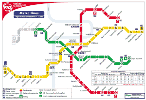
Prague metro, officially known as “Pražské metro”, It is the underground transportation system that connects the capital of the Czech Republic.
Inaugurated on 9 May 1974, This system has experienced constant expansion, with the last extension carried out in 2023, due to the increasing demand for transportation.
At the moment, has 3 lines that cover 61 stations along 65,2 kilometres (about 40,51 miles), allowing wider access to the entire city.
subway map
Here's the Prague metro map. Click on the image to make it larger:
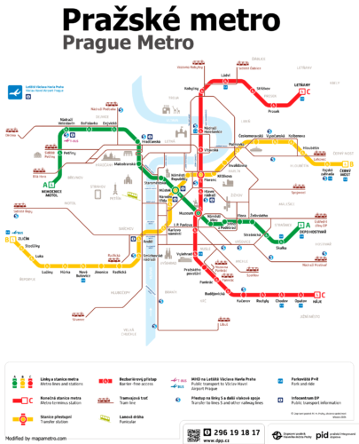
We also have the Prague metro map in PDF.
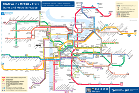
Prague metro and tram lines map:
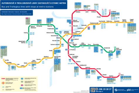
Map of metro and public transport lines in suburban areas of Prague:
Official Web site
- For more information, visit the Prague metro official site.
- You can also consult a Complete list of all Prague attractions. Surely there are things that you didn't even know existed..
Prague metro timetable
The Prague metro has the following schedules:
- Every day: of 5:00h until 0:00h.
Rates
Prague metro offers several options for passengers:
| Type | Precio | Details |
|---|---|---|
| One-way ticket | 30 CZK (~1.30 USD) | a single trip. |
| Bill of 90 min | 40 CZK (~1.73 USD) | trips during 90 minutes in any medium. |
| Bill of 24 h | 120 CZK (~5.19 USD) | Unlimited trips for one day. |
| Monthly payment | 550 CZK (~23.79 USD) | Unlimited trips for one month. |
History of the subway
Prague metro, inaugurated on 9 May 1974, started with Line C. Initially, This line connected the stations of Kačerov a Florenc. This event marked a milestone in the urban development of Prague, thus introducing a modern solution for the mobility needs of its growing population.
Expansion and development
Unlike the system of Vienna metro, which evolved from a network initially operated by steam locomotives from the late 19th century, The Prague metro was a later development, planned and built to meet modern demands for efficient urban transportation.
Beginnings and initial expansion
The system began with Line C, which initially connected Kačerov con Florenc. This line, specifically designed to facilitate quick access through key areas of the city, significantly improved connectivity. Posteriorly, Lines A and B were developed in response to the growing need for a broader network:
- Line A: Inaugurated in 1978, connected Dejvická con Náměstí Míru, gradually expanding in subsequent years.
- Line B: It started operating in 1985, uniting Florenc con Smíchovské nádraží and later spreading to other areas.
Political changes and modernization
During the socialist era, The subway's design and expansion were closely aligned with industrial and central planning needs. However, the Velvet Revolution 1989 marked a turning point, triggering a series of modernizations in metro infrastructure and services. This included the renovation of stations, improving operational security and introducing modern ticketing and access control technologies.
Continuous modernization
Throughout the decades of 1990 y 2000, Prague metro continued to evolve to improve efficiency and user comfort. Automated systems and more modern rolling stock were incorporated, which increased the frequency and capacity of the lines, thereby improving the overall user experience.
Future planning and expansion
The system continues to grow; Plans are being made for the new Line D that will improve the connection between the center and the southern neighborhoods to make transportation more accessible. This project will help reduce traffic on existing lines and provide better service to areas that now have less coverage.. In the following map you can see the current lines and future lines:
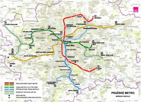
History of the Prague metro map
The initial design of the Prague metro map, work of František Kolář y Jiří Lampa, focused exclusively on Line C, reflecting his journey from Kačerov until Florenc because it was the main line at that time.
This map was the one used by the first subway users in 1974. I have not been able to find any copy of this map, however, in case someone finds it, Leave me the link in the comments.
Evolution and adaptation of the map
With the expansion of the system and the inauguration of Line A in 1978 and Line B in 1985, the map evolved to integrate these new routes. Besides, a color system was adopted to facilitate the distinction between lines: green for Line A, yellow for Line B and red for Line C.
On the other hand, The map layout received significant updates in 1985 with the addition of Line B. In addition, Refined graphical elements to provide a clearer and more detailed representation of the expanding network. These modifications allowed users to better understand the interconnections and plan their routes more effectively..
Modernization and visual clarity
As Prague continued to expand its metro network, The map design was also adapted to incorporate new stations and lines, including planning for the future Line D.
Additional data
The Prague Metro efficiently connects the city's main points of interest:
Places on line A
- Vytopna Railway Restaurant (season “Můstek“, Prague metro lines A and B): It is located in the Plaza de Wenceslao in Prague, Czech Republic. This place stands out because, through toy trains, They deliver food and drinks directly to the tables.
- Bridge of Carlos: Can be accessed from the station Malostranská on Line A.
- Astronomical clock: Located in the Old Town Square, the clock is conveniently located a short distance from the station Staroměstská (Line A).
- Prague Castle: This famous complex is close to the station Hradčanská, on the same Line A.
Line B
- Jewish Quarter: Accessible from the station Staroměstská, on Line A, o Náměstí Republiky, on Line B.
- Dancing House (Tančící dům): For lovers of modern architecture, he Dancing House It is accessible from the station Karlovo Náměstí on Line B.
- Old Town Square: Near Staroměstská stations (Line A) y Republic Square (Line B).
- O2 Arena: Located near the metro station Českomoravská on Line B, the O2 Arena It is an important center for events and concerts.
- Centrum Černý Most: Large shopping center located near the metro station Černý Most (Line B), offering a variety of shopping and entertainment.
Line C
- National Museum (National Museum): It's right next to the station Muzeum (lines A and C), there they have collections of cultural and historical artifacts.
- Vyšehrad Castle: For a dose of history, you can visit the castle Vyšehrad, close to the station Vyšehrad on Line C. Besides the castle, the area offers beautiful views of the river Vltava and the city.
- PVA Expo Praha in Letňany: It is a place for fairs and exhibitions, accessible from the station Letňany on Line C.
- National Technical Museum: For those interested in technology and engineering, this museum offers exhibitions and is close to the station Vltavská (Line C).
Old Prague metro maps
In a historical way we will hang the old subway maps here, in this case of the year 2012:
