Warsaw metro (officially called Metro Warszawskie) is the underground rapid transit system that serves the capital of Poland.
Inaugurated on 7 April 1995, The metro consists of two main lines: Line M1, that connects the north and south of the city, and Line M2, that crosses from east to west.
Total, the system has 43 stations along 41 km (25.5 miles) of roads. Operated by Metro Warszawskie, The metro plays a crucial role in the daily mobility of Warsaw residents and visitors, providing an efficient and punctual means of transportation.
subway map
Below we show you the Warsaw metro map. Click on the image to make it larger:
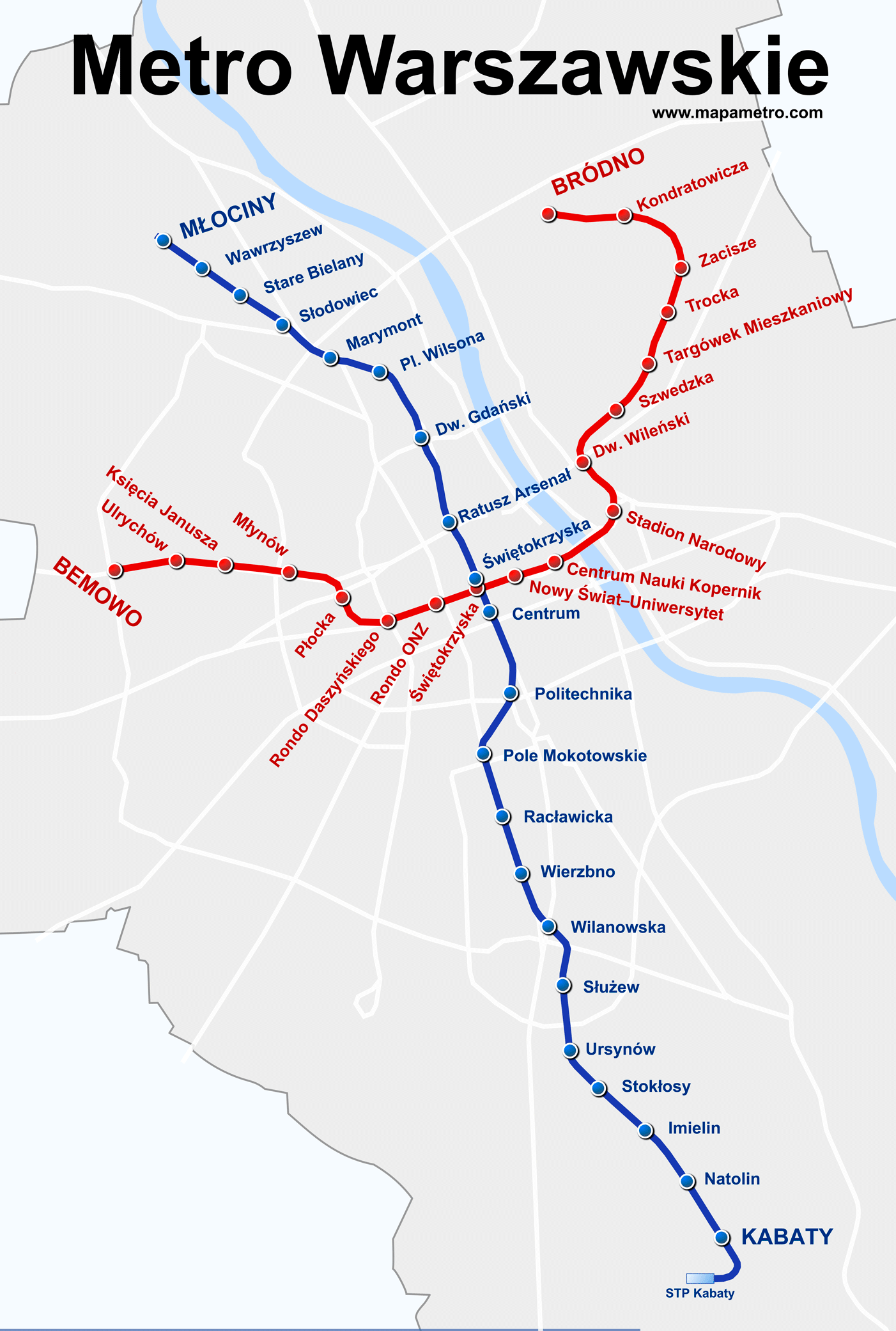
If you wish you can download the previous one Warsaw metro map in PDF format.
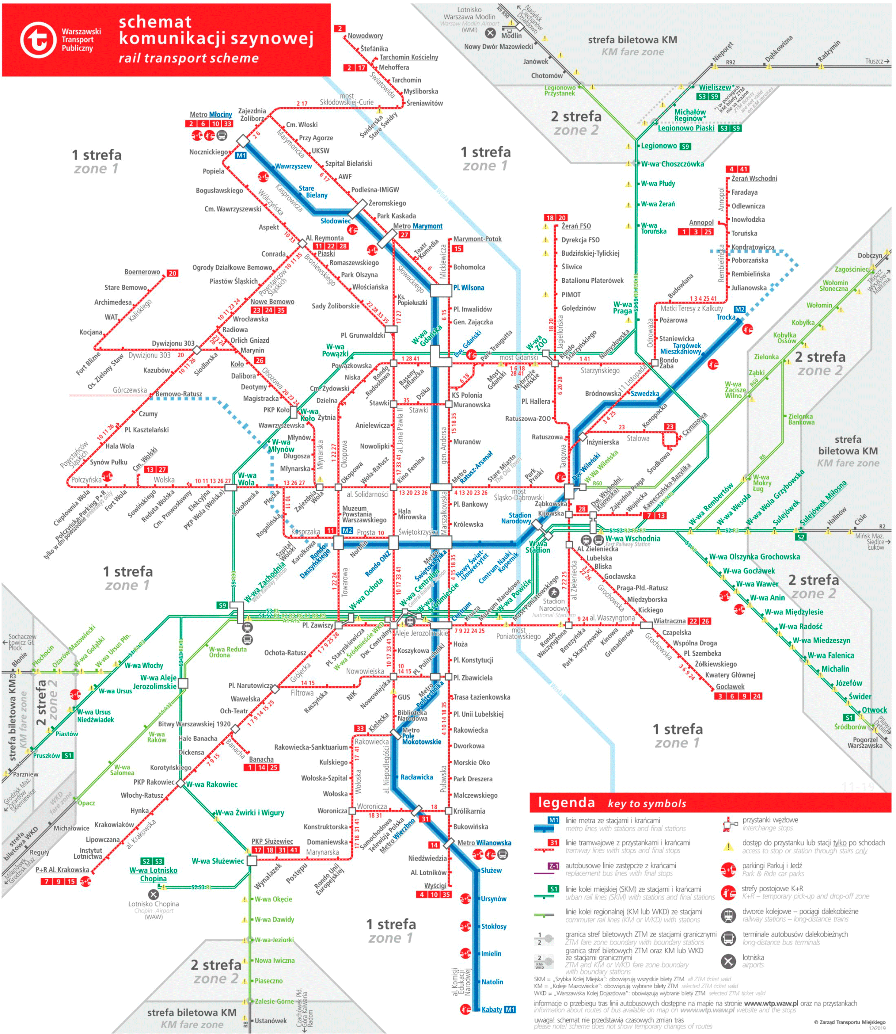
And the following is the map of the Warsaw railway network:
Warsaw metro timetable
- Weekdays and Saturdays: 5:00h a 0:00h
- Sundays and holidays: 5:00h a 23:00h
Rates
Warsaw metro fares vary, offering options for different needs. Here you have a table with the main prices:
| Type of Bill | Precio (PLN) | Precio (USD) |
|---|---|---|
| Bill of 20 minutes | 3,40 PLN | 0.80 USD |
| Bill of 75 minutes | 4,40 PLN | 1.03 USD |
| Bill of 90 minutes | 7,00 PLN | 1.63 USD |
| daily ticket (24h) | 15,00 PLN | 3.50 USD |
| Bill of 3 days (72h) | 36,00 PLN | 8.40 USD |
| weekend ticket | 24,00 PLN | 5.60 USD |
Besides, there are special cards and discounts. The students, People with disabilities and other specific groups can access reduced rates. Tourists can benefit from tickets 24 hours and 3 days, that allow unlimited trips within the validity period.
Official Web site
- Official website of the Warsaw metro.
- Website with all attractions and shows in Warsaw.
History of the subway
Plans for a metro in Warsaw emerged in 1918, but the Great Depression and World War II postponed its construction.
The Warsaw metro began to take shape in 1925 con la Warsaw Tramway Authority, who started the first plans.
In 1938, under mayor Stefan Starzyński, tunnels began to be built, But World War II stopped the project..
Upon reaching the decade of 1950, the communists resumed plans with a military focus, but these were canceled due to high costs.
In 1984, construction of the subway resumed under the communist regime, and the first line (M1) was inaugurated in 1995, conectando Kabaty y Politechnika.
The line extended northwards between 2003 y 2008, reaching Młociny. Construction of Line M2 began in 2010, with Astaldi leading the project. It was inaugurated in 2015, connecting the east and west of the city.
Extensions of the M2 began in 2019 and more are expected until 2026. The company Kazimierski i Ryba designed outstanding stations such as Pl. Wilson, recognized for its unique architecture. Wojciech Fangor contributed to the aesthetic design of the stations, while the construction companies Astaldi and Gülermak İnşaat carried out the main works.
Warsaw Metro Map History
The Warsaw metro map has its roots in the plans of 1925, created by the Warsaw Tramway Authority. In 1934, Stefan Starzyński revitalized these plans, although the war cut short their progress. After several failed attempts, The first line was inaugurated in 1995.
The modern design of the stations and the current map is largely due to renowned Polish artist Wojciech Fangor, who designed the color and typography schemes.
The architectural firm Kazimierski i Ryba also contributed significantly, designing modern stations that have gained international recognition. Astaldi and Gülermak İnşaat companies participated in the construction and upgrade of the system.
Warsaw metro lines in 2024
The Warsaw Metro currently has two operational lines, M1 y M2, and plans to expand with new lines in the future. Here you have a summary of the stations of both lines:
M1 line (Młociny – Kabaty)
- Młociny
- Wawrzyszew
- Stare Bielany
- Słodowiec
- Marymont
- Wilson Square
- Gdański Railway Station
- City Hall Arsenal
- Świętokrzyska
- Center
- University of Technology
- Pole Mokotowskie
- Racławicka
- Wierzbno
- Wilanowska
- Służew
- Ursynów
- Stokłosy
- I loved it
- Natolin
- Kabaty
M2 line (Bemowo – dirty)
- Bemowo
- Ulrychów
- Prince Janusz
- Młynów
- Płock
- Rondo Daszyńskiego
- Rondo ONZ
- Świętokrzyska
- Nowy Świat-University
- kopernik Science Center
- National Stadium
- Vilnius Railway Station
- Swedish
- Targówek Mieszkaniowy
- Trotsky
- Retreat
- Kondratowicz
- dirty
Additional data
The Warsaw Metro is known for its varied architectural design, with stations ranging from modern designs to Soviet-era influences. some stations, like Pl. Wilson, They have been internationally recognized for their architecture.
The system has also contributed significantly to the urban development of Warsaw, improving accessibility and attracting investment in areas along its routes. Besides, The metro integrates perfectly with other modes of public transportation, facilitating transfers between trains, trams and buses.
The main tourist attractions in Warsaw are these:
- Royal Castle (Ratusz Arsenał, Linia M1): A majestic restored castle, residence of Polish kings and venue of important historical and cultural events.
- Royal bathroom (Politechnika, Linia M1): Park and palace of the last king of Poland, famous for its open-air Chopin concerts and historic architecture.
- Palace of Culture and Science (Centrum, Linia M1): The tallest building in Poland, with panoramic viewpoint, theaters, cinemas and museums. It is a symbol of Warsaw.
- Warsaw Uprising Museum (Rondo Daszyńskiego, Linia M2): Modern museum dedicated to the rebellion of 1944, with interactive exhibits that tell the story of the uprising.
- kopernik Science Center (Centrum Nauki Kopernik, Linia M2): Interactive science center, Ideal for all ages, with planetarium and practical experiments.
- Mermaid Monument (Ratusz Arsenał, Linia M1): Iconic mermaid statue, Warsaw symbol, located in the Market Square of the Old City.
- Vistula Boulevards (Centrum Nauki Kopernik, Linia M2): Walk along the Vistula River with cafes, bicycle lanes and recreation areas. Perfect for a relaxing walk.