The Santiago metro, officially known as “metro de Santiago“, It is the underground transportation system in the capital of Chile. Inaugurated in 1975, has gone through a series of expansions, with the most recent in September of the year 2023.
The system currently has 7 lines, 136 stations, and covers 103 kilometres (about 64.00 miles). It is one of the fundamental pillars for the daily transportation of millions of passengers who move through the city..
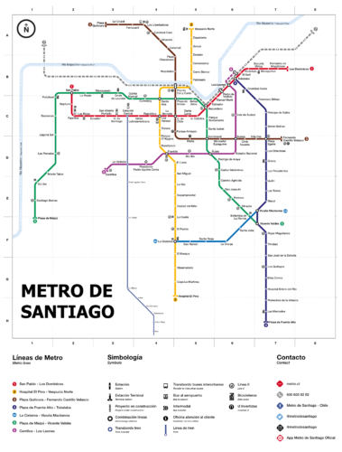
subway map
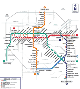
Here's the Santiago metro map in two different versions. Click on the image to see it larger:

We also have the same Santiago metro map in PDF format.
Santiago metro schedules
The Santiago metro operates with the following schedules:
| Day | Time |
|---|---|
| Work days | 6:00 am – 11:00 pm |
| Saturdays | 6:30 am – 11:00 pm |
| Sundays and holidays | 8:00 am – 11:00 pm |
Rates
The system offers different rates depending on the time of day, the schedules of the different tariff periods. As a curiosity, of all the meters that we have on this website, This is the most complicated pricing system on the entire planet..
The schedules are as follows:
- 06:30 – 07:00: Valley Schedule (tomorrow)
- 07:00 – 09:00: Peak Hours (tomorrow)
- 09:00 – 18:00: Valley Schedule (average)
- 18:00 – 20:00: Peak Hours (afternoon)
- 20:00 – 21:00: Valley Schedule (evening)
- 21:00 – 23:00: Low Hours (evening)
And these are the prices according to the time of day:
Santiago metro fares (2024)
| Rate Type | Price in CLP | Price in USD |
|---|---|---|
| Rush hour | 800 CLP | 0.96 USD |
| Valley Time | 750 CLP | 0.90 USD |
| Low Hour | 640 CLP | 0.77 USD |
| Reduced rate | 370 CLP | 0.44 USD |
| Student Rate | 210 CLP | 0.25 USD |
There are special passes and rates for seniors and students..
Special cards
- Card Bip!: It is the official means of payment for the Santiago Metro and other public transport in the city.. It is rechargeable and can be purchased at metro stations and authorized points of sale..
- metro card TNE (National Student Card): Available for basic education students, middle and upper. Offers reduced rates at all times.
- Senior Citizen Card: Offers significant discounts for seniors 65 years. The card can be requested by presenting the identity document at the metro customer service centers.
- Tourist Card: This card provides tourists with unlimited access for a certain period (1, 3 o 7 days). It is ideal for those who plan to visit several places in Santiago and want to get around the city easily. Available in main stations and tourist offices.
Official Web site
For more information, you can visit the official website of the Santiago metro.
History of the Santiago metro
The idea of a metro in Santiago dates back to the beginning of the 20th century, when different plans were explored to improve urban mobility. However, it was in the years 60 when the final decision was made. In 1965, the Chilean government hired the French company SOFRETU to design a master plan that included three urban lines and two suburban lines. In 1968, President Eduardo Frei Montalva officially approved the project.
The construction of the Line 1 started on 1969 and its first section, between the seasons San Pablo y La Moneda, The 15 September 1975. This line crossed the city center from east to west, significantly relieving traffic congestion. The construction company was DUMEZ-SOGEA, with the supervision of Chilean and French engineers.
In 1978, the line was opened 2, which initially operated on the surface and later extended underground to the south. This line joined Los Héroes con Franklin and then Lo Ovalle. Population growth in the southeast of Santiago prompted the need for more expansions.
The decade of 80 was marked by the economic crisis and a devastating earthquake in 1985, which slowed down planned expansions. Despite this, new stations were opened on the Line 2, as Santa Ana y Puente Cal y Canto. In 1989, the metro became a public company under the name Metro S.A..
The line 5 was inaugurated in 1997, initially from Baquedano until Bellavista de La Florida, and spread in the 2000 to cross the historic center. In 2002, construction of the line began 4, intended to connect Santiago with Puente Alto. This line was inaugurated in 2005 and was complemented with a branch, Line 4A, in 2006.
XXI century
The 21st century brought more expansions. In 2010, the extension of the line was opened 5 towards Pudahuel and in 2011, arrival completed Maipú. The lines 6 y 3 They began construction in 2012, introducing new technologies and significantly improving network capacity. The line 6 was inaugurated in 2017 and the line 3 in 2019.
In 2023, important expansions were completed, as the extension of the Line 2 towards the south and the Line 3 northward, continuing with the commitment to improve mobility in Santiago.
The last station that has been inaugurated in the Santiago metro is the station Plaza Quilicura. This station is part of the extension of the Line 3 and was inaugurated on 25 September 2023.
History of the Santiago metro map
The Santiago metro map has been an essential tool since its beginnings in 1975. Its design has evolved along with the expansion of the system, and several actors have contributed to its development over the years.
The first subway map was designed in the late 1990s. 60 by the chilean Santiago Arias, who established a visual standard that stood for several decades. This initial design was simple but effective, helping users navigate the newly inaugurated Line 1, that connected San Pablo con La Moneda.
With the opening of new lines in the years 70 y 80, the map was adapted to include these expansions. The line 2 was inaugurated in 1978 and was added to the map. This line originally operated above ground and was later extended underground..
In the years 90, with the opening of the Line 5 in 1997, The map underwent a significant revision to reflect the new connections. The expansion towards the historic center of Santiago and the introduction of distinctive colors for each line made the map more intuitive for users.. This era also saw the incorporation of more sophisticated graphic elements, designed by multidisciplinary teams that included engineers, graphic designers and urban planners.
XXI century
The turn of the millennium brought with it the inauguration of the Line 4 in 2005, which led to another major map update. This time, the french company RATP Dev collaborated with Santiago metro to ensure that the map design was not only functional, but also aesthetically pleasing and easy to understand for users.
In 2010, A modernization of the map was carried out to include the extension of the Line 5 until Maipú. This redesign included improvements in readability and the addition of icons for points of interest near the stations, like hospitals, parks and cultural centers.
Recently, with the opening of the Lines 6 y 3 in 2017 y 2019 respectively, the subway map was updated again. These changes not only added new routes, but also improved user interaction with the map through mobile applications and digital formats accessible online.
With the projection of new lines such as 7, 8 y 9, It is expected that the map design will continue to change and improve.
Additional data
Along the Santiago metro stations, you can find works of art, live music and a sample of Chilean culture. The most iconic stations include Baquedano, an important connection point between several lines, y Los Dominicos, known for its proximity to the park of the same name, a perfect place to enjoy nature and local crafts.
Besides, the metro contributes significantly to tourism, facilitating access to historical sites such as the Centro Cultural La Moneda and the Cerro Santa Lucía.
Some key stations connect to places of great interest, as:
- La Moneda Palace (Season La Moneda, Line 1): Government center with outstanding history and architecture.
- Santa Lucia Hill (Season Santa Lucía, Line 1): Historic hill with viewpoints and gardens.
- Main Square (Season Plaza de Armas, Line 5): Historic center with the Metropolitan Cathedral.
- Barrio Bellavista (Season Baquedano, Line 1 y 5): Bohemian area with bars, restaurants and culture.
- National museum of fine arts (Season Bellas Artes, Line 5): Chilean art and international exhibitions.
- Cerro San Cristóbal (Season Baquedano, Line 1 y 5): Urban park with cable car and zoo.
- Central Market (Season Cal y Canto, Line 2): Traditional market famous for its fresh seafood.
- Parque Bicentenario (Season Tobalaba, Line 1 y 4): Extensive park with lagoons and picnic areas.
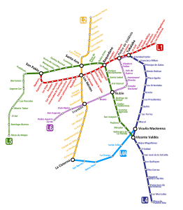
Old maps of the Santiago metro
In historical mode, we are hanging the old subway maps, in this case they are from the year 2014:


