The São Paulo metro is the urban transport system for the city of São Paulo, Brazil.
This system, Colloquially known as “metrô de São Paulo” and officially as “Companhia do Metropolitano de São Paulo“, has a network that extends 104,4 kilometres (64,9 miles). Inaugurated in 1974, It has become an essential element for the city.
With six lines and 89 stations, São Paulo metro connects key areas of the city, facilitating the daily transit of some 4 million passengers (year data 2023).
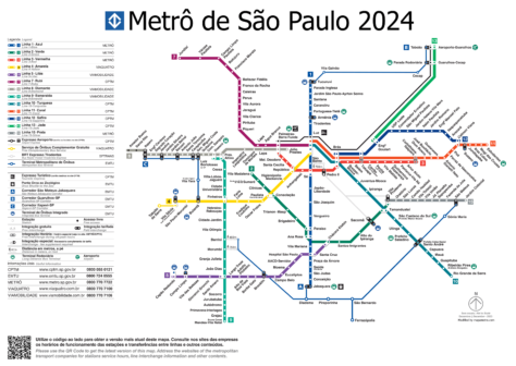
subway map
Below we show you the São Paulo metro map. Click on the image to see it larger:

Version of the São Paulo metro map in PDF format.
Official Web site
- For more information, visit the official website of the São Paulo metro.
São Paulo metro schedule
- Monday to Saturday: 5:00 AM – 12:00 AM
- Sundays and holidays: 6:00 AM – 11:00 PM
São Paulo metro prices
From the 1 January 2024, São Paulo metro fares have been updated to reflect the increase in operating costs. Next, A table is presented with the main prices in Brazilian reals (R$) and its approximate equivalent in US dollars (USD) so that tourists get a better idea of the price:
| Type of ticket | Precio (BRL) | Precio (USD) |
|---|---|---|
| Single Ticket (basic fare) | R$ 5,00 | $1,00 |
| Single Ticket (transportation vouchers) | R$ 5,49 | $1,10 |
| Single school ticket (per trip) | R$ 2,50 | $0,50 |
| Integrated Rate (subway and bus) | R$ 8,20 | $1,64 |
| Early bird rate | R$ 4,40 | $0,88 |
| Integrated early bird rate | R$ 7,30 | $1,46 |
| Ticket 24 Hours | R$ 19,00 | $3,80 |
| Ticket 24 Integrated hours | R$ 24,00 | $4,80 |
| Single monthly ticket | R$ 243,00 | $48,60 |
| Integrated monthly single ticket | R$ 362,00 | $72,40 |
Besides, There are several special cards that offer discounts and additional facilities:
- Cartão Fidelidade:
- M8: R$ 37,00 ($7,40 USD)M20: R$ 90,00 ($18,00 USD)M50: R$ 217,00 ($43,40 USD)
- M8: R$ 37,00 ($7,40 USD)
- M20: R$ 90,00 ($18,00 USD)
- M50: R$ 217,00 ($43,40 USD)
- Cartão Lazer M10: Special for leisure trips, costs R$ 43,50 ($8,70 USD).
- Tarifa del Madrugador: A reduced fare for early travel, with a cost of R$ 4,40 ($0,88 USD).
Rates allow for multiple payment options, including contactless debit and credit cards, as well as electronic wallets, making the system even easier to use.
History of the São Paulo metro
The project to have a subway in São Paulo began in the years 60, in response to the exponential growth of São Paulo. In 1968, was founded Companhia do Metropolitano de São Paulo. The construction of “the line 1 – Blue”, originally called North-South Line, started in 1969.
The São Paulo metro was inaugurated on 14 September 1974, The inaugural section was Jabaquara a Vila Mariana.
Years 80‘
The “Line 1” spread northward, arriving to Santana in 1975 and finally to Tucuruvi in 1998. Meanwhile, in 1979 was inaugurated “Line 3 – Red”, uniting Itaquera y Barra Funda, responding to the growing demand for transportation in the east and west areas of the city.
Years 90‘
The “Line 2 – Green” started operating in 1991, initially connecting Ana Rosa y Consolação. This line expanded to Vila Madalena in 1998 and later until Vila Prudente in 2010. During this decade, future lines were also planned 4 y 5, although the works on these lines would face several challenges and delays.
2000-2010: Modernization and automation
The “Line 5 – Lilás” opened its first section between Capão Redondo y Largo Treze in 2002. This project was planned since years 80, but it was finalized much later due to financial and technical difficulties. The line was eventually extended to Chácara Klabin in 2019, integrating with the lines 1 y 2.
The “Line 4 – Yellow”, the first fully automated line in Latin America, inaugurated its first section in 2010. Connect Luz con Vila Sônia and has been managed by the private company ViaQuatro, Part of Grupo CCR.
2010-2020: expansion and concessions
During this decade, major expansions completed. The “Line 15 – Silver”, a monorail system, was inaugurated in 2014. This innovative project sought to alleviate congestion in the eastern area of São Paulo. Besides, the line 6 – Orange began its construction, although it has faced several delays and its opening is expected in the coming years.
The last inaugurated station of the São Paulo metro, it's the season Jardim Colonial On the line “15 – Silver”. It was inaugurated on 29 December 2021.
History of the São Paulo metro map
The first subway map, launched in conjunction with the inauguration of the “Line 1 – Blue” in 1974, It was a simple but effective performance.. Designed in-house by Companhia do Metropolitano from Sao Paulo, This initial map highlighted the first stations between Jabaquara y Vila Mariana, and later on, until Tucuruvi.
Decade of the 80: Extensions and new designs
With the opening of the “Line 3 – Red” in 1979, The map was updated to include this new line, that united Itaquera y Barra Funda. During this decade, The map became more complex and modern design elements were incorporated to make the expanding system easier to understand..
Years 90: New standards
In the years 90, with the expansion of the “Line 2 – Green” and plans for future lines, the subway map was redesigned again. This time, Distinctive colors were included for each line, following international metro map design standards. Besides, began working with external design studios to improve the clarity and functionality of the map. We have not been able to find who these were “External designer studios”.
2000-2010: Modernization and automation
The decade of 2000 saw the introduction of the “Line 5 – Lilás” and the “Line 4 – Yellow”, the first automated line. The maps were updated to reflect these additions and to incorporate new printing and digital design technologies.. Companies like ViaQuatro, responsible for the line 4, They collaborated on the design of maps that included details about the automation and special features of this line.
2010 onwards: digitization and continuous expansion
In the last decade, the subway map has undergone a digital transformation. Mobile applications and interactive versions of the map were developed, facilitating access to information in real time. Inclusion in the year 2021 of the “Line 15 – Silver”, a monorail system, It also marked a milestone in map design, highlighting its unique route and its integration with the other metro lines.
Additional data
The metro passes near important tourist sites such as the Municipal Market, Paulista Avenue and Ibirapuera Park. The trains are modern and have air conditioning systems and free Wi-Fi, providing convenience to users.
These are the most visited and important places in São Paulo, which are easily accessible by subway:
- Paulista Avenue (Trianon-Masp station, Green Line): Financial heart of the city, full of museums, theaters, and restaurants.
- Ibirapuera park (Season AACD-Servidor, Lilas Line): The most famous park in São Paulo, ideal for outdoor activities and cultural events.
- Catedral da Sé (Sé Station, Blue line): Impressive neo-gothic church, located in the historic center of São Paulo.
- São Paulo Art Museum – MASP (Season Trianon-Masp, Green Line): modern architecture icon, houses an impressive art collection.
- São Paulo Municipal Market (Season São Bento, Blue line): Known for its enormous variety of fruits, spices and the famous mortadella sandwich.
- Bairro da Liberdade (Season Liberdade, Blue line): Japanese quarter with markets, traditional shops and festivals.
- Theatro Municipal (Season Anhangabaú, Red Line): Beautiful theater inspired by the Paris Opera, cultural epicenter of the city.
- São Paulo art gallery (Season Luz, Blue line): Brazilian art museum, noted for its exhibitions and historic architecture.
Old metro maps of São Paulo
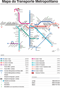
In a historical way we are hanging the old subway maps in this section, in this case of the year 2014.

