Hamburg metro, officially known as “Hamburger U-Bahn”, is the underground transportation system that serves the city of Hamburg, Germany.
Inaugurated on 1 March 1912, has grown to include 4 lines that connect 93 stations. The network covers a length of 106.4 kilometres (about 66.11 miles) and is essential for the daily transportation of residents and tourists.
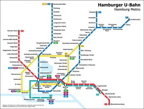
Here's the Hamburg metro map. Click on the map to see it well:

- We have the previous one Hamburg metro map in PDF format.
- Based on ‘Network map of the Hamburg subway‘ de Arbalete under CC BY-SA 4.0. Modified by Mapametro.com under the same use license.
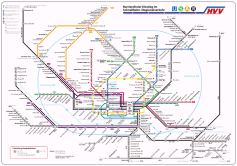
And the following Hamburg metro map, in addition to having all the transportation lines by road, also shows stations adapted for people with wheelchairs, suitcases or baby strollers.
Click image to enlarge:

We also have the map version in PDF format.
Hamburg metro timetables
The Hamburg metro operates with the following schedules:
- Every day: continuous service 24 hours with different frequencies.
Rates
The subway offers several options for passengers:
| Type of ticket | Tarifa Zones | Precio (€) | Precio (USD) |
|---|---|---|---|
| One-way ticket | 1-2 zones | 3.80€ | $4.07 |
| Day ticket from 09:00h | 1-2 zones | 7.50€ | $8.03 |
| Full day ticket | 1-2 zones | 8.80€ | $9.42 |
| Group ticket from 09:00h | 1-2 zones | 14.10€ | $15.09 |
Day tickets and group tickets are valid from midnight to 6 am the next day and all day on weekends and holidays. A day ticket allows one adult and up to three children between 6 y 14 years travel all day.
Besides, he Hamburg CARD It is especially useful for tourists. This card allows unlimited travel on buses, trains and ferries from the port and offers discounts of up to 50% in more than 150 attractions. The prices of the Hamburg CARD start in 11.90 € ($12.73) and are available in options 1 a 5 days for both individuals and groups.
Official Web site
- For more information, visit the official site of the Hamburg metro.
- To see a list of all tourist attractions what's in Hamburg, we recommend using this website, sometimes they have very interesting things.
History of the subway
The history of the Hamburg metro, started at the beginning of the 20th century, being a crucial element for the city's urban transportation. In 1906, The Hamburg Senate awarded a contract for the construction of an elevated and underground railway system to Siemens & Halske y AEG. The first section was completed in 1906, and in 1911 the company was founded Hamburger Hochbahn AG.
Finally the goal was achieved after so many efforts, y he 1 March 1912 the metro was inaugurated. This network connected various parts of the city through a combination of elevated and underground sections..
The line U1, For example, was inaugurated in 1914 and has been extended on multiple occasions until Norderstedt Mitte in 1996. The line U4 It is more recent and began operating in 2012, connecting the city center with the new area of HafenCity and beyond until Elbbrücken.
The development of the U-Bahn not only reflects the technical and urban growth of Hamburg, but also the historical events it has gone through, such as the damage suffered during the bombings of World War II, that profoundly affected the city's infrastructure.
Last extension made
The last station opened in the Hamburg metro is the station Elbbrücken of line U4. This station opened to the public on 7 December 2018. It is part of an extension of line U4 that connects the city center with the district of HafenCity
Future of the Hamburg metro
Looking to the future, One of the most ambitious projects is the construction of the Line U5, which is planned to connect areas of the northeast and northwest with the city center, including important infrastructure such as the main station (Hauptbahnhof), exhibition pavilions, the university and the university hospital UKE. The U5 will be completely automated, which will allow a train frequency of up to every 90 seconds in peak hours, providing significant relief to the city's overcrowded main roads and bus lines. Construction of line U5 began at the end of 2021 and is expected to be completed in several phases until 2035.
Besides, the Line U4 is also being extended, with plans to add new stations and extending south to Wilhelmsburg y Kirchdorf, and towards the east until Horner Geest.
History of the Hamburg subway map
Among its first designers stands out Emil Schumann, a pioneer in transportation mapping who worked to simplify the presentation of original routes. During the early 20th century it updated its map periodically with the expansion of new lines and stations..
In the decade of 1960, after the introduction of Line U2, The map design was standardized with a “diagram style” which made it easier to read.
Other designers and cartographers have contributed to the refinement of its modern style., as Hans Joachim Helm, who in the years 80 Improved visual clarity by reducing graphical clutter.
Besides, Some maps used by Hamburg's transportation systems are based on data from OpenStreetMap, which are open source and editable by the public, indicating a collaborative and up-to-date approach in creating and maintaining these visual resources.
At the moment, although we have not found the specific individuals who have made the improvements during the 21st century, It is evident that the design and maintenance of metro maps is a continuous effort that involves graphic design and cartography professionals., coordinated by Hamburg transport entities such as Hamburger Hochbahn y Hamburger Verkehrsverbund.
Additional data
Hamburg's metro connects passengers to some of the city's most iconic landmarks:
- Port of Hamburg: Can be accessed from the station Landungsbrücken, Located in the heart of port activity and an excellent starting point for exploring the seafront.
- Miniatur Wunderland: The nearest station is Baumwall, facilitating access to this world famous attraction.
- City of Altona: Altona It is a station that connects with this important district, home of markets, cafes and rich history.
- Park Planten un Blomen: Station Stephansplatz provides direct access to this green oasis, ideal for a relaxing walk.
- Elbphilharmonie: Station Baumwall offers a quick connection to this architectural gem, famous for its design and acoustics.
Old Hamburg subway maps
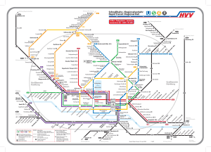
In a historical way we will hang the old subway maps in this section, at the moment we have this one of the year 2014. Click on it to enlarge it:

