The Lyon metro, officially known as “Métro de Lyon“, operates in the city of Lyon, France.
This metro system is essential for urban transportation and was inaugurated on 28 April 1978. At the moment, the metro has 4 lines that cover 32.1 kilometres (19.9 miles) y 44 stations in total.
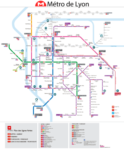
subway map
Below we show you the Lyon metro map, click on the image to see it larger:

Version of the Lyon metro map in PDF format.
Official Web site
- For more information, visit the official website: www.tcl.fr
- List of all the attractions of Lyon.
Schedules
- Weekdays and Saturdays: 5h00 – 0h00
- Sundays and holidays: 6h00 – 0h00
Rates
Here is a table with the main prices in euros, with its equivalent in US dollars in parentheses so that tourists have a better idea:
| Subscription Type | Price in EUR | Price in USD |
|---|---|---|
| One-way ticket (1 hour) | 1.90 € | 2.08 $ |
| Checkbook 10 tickets | 17.60 € | 19.30 $ |
| Ticket valid for 2 hours | 3.30 € | 3.62 $ |
| night ticket | 3.50 € | 3.84 $ |
| Ticket valid for 24 hours | 6.00 € | 6.58 $ |
| Ticket valid for 48 hours | 12.00 € | 13.16 $ |
| Ticket valid for 72 hours | 16.50 € | 18.09 $ |
| Funicular round trip ticket | 3.00 € | 3.29 $ |
Children under 4 years travel free on public transport in Lyon.
Special cards
- Lyon City Card: This card is ideal for tourists. Offers unlimited trips on Lyon public transport while active. Besides, includes free admission and discounts at many tourist attractions in the city. You can buy it for 1, 2, 3 o 4 days.
Tickets can be purchased at self-sale machines located in metro and tram stations., as well as in the TCL offices distributed throughout the city.
History of the subway
The Métro de Lyon, one of the city's main transportation systems, began to take shape in the mid-20th century. Planning intensified in the decade 1960 due to the need for efficient transportation for an expanding city.
Line A
Construction of Line A began in 1973 and was inaugurated on 2 May 1978. This line, what goes from Perrache to Vaulx-en-Velin La Soie, It was developed by the company Matra, using the cut and cover method. The trains on this line operate on rubber tires, a distinctive feature of the Lyon system.
Line B
Line B was also inaugurated on 2 May 1978, connecting Charpennes with Part-Dieu. In 1981, extended to Jean Macé and, subsequently, in 2000, to Stade de Gerland. The most recent extension, to Gare d'Oullins, was completed in 2013. This line also uses trains with rubber tires and, from 2022, operates in an automated manner with the new MPL rolling stock 16 from Alstom.
Line C
Line C is unique because of its history. Originally, a cog railway known as Croix-Rousse – Cross Package, was adapted and integrated into the metro system in 1974. It was officially inaugurated as part of the metro on 6 December 1974. and extended to Cuire in 1984. This line uses steel wheels and a combination of different construction methods, including deep tunnels and open-air sections.
Line D
The D Line, inaugurated on 4 September 1991, It was the first fully automatic line in France. Initially, operated with drivers between Gorge de Loup y Grange Blanche, but in 1992 became completely automatic. This line, which crosses the Rhône and Saône rivers, extended to Gare de Vaise in 1997, becoming the longest line in the system with 12.6 kilometers and 15 stations. Use the system MAGGALY for automatic operation, without platform doors, which is unusual for an automated subway.
Engineers and construction companies
Various companies have participated in the construction of the Lyon metro. Matra, known for its advances in transportation technologies, played a crucial role in the early stages. Alstom was instrumental in recent upgrades, especially with the introduction of MPL automated rolling stock 16. The current operator of the system is Keolis Lyon, under the brand TCL (Transports en Commun Lyonnais), which will manage the metro until RATP Dev takes over in 2025.
History of the Lyon metro map
The Lyon metro map has an interesting history dating back to the late 19th century. In 1885, the engineer Joseph Jaubert presented the first metro project in Lyon, that sought to complement the tram lines of the time. Although this initial project was not carried out, laid the foundation for future developments.
Years 60
In the years 60, The growing traffic problem in Lyon led to the need for a more efficient transportation system. In 1963, engineer René Waldmann from the Ponts et Chaussées management began working on the metro project. This project was finally supported by the mayor of Lyon, Louis Pradel, who promoted its realization.
The first studies and design of the metro map were carried out by the SOFRETU, a subsidiary of the Régie Autonome des Transports Parisiens (RATP), with René Waldmann supervising the technical aspects. In 1967, the Lyon agglomeration community was founded (COURLY) and in 1968 was created Société d’économie mixte de l’agglomération lyonnaise (SEMALY), in charge of the conception of the new metro.
Years 90 to the present
In the decade of 1990, Line D was introduced, the first fully automated line in France, which began operating in 1991.
From 1991, The subway map has continued to evolve with several expansions. In 2007, line A was extended to Vaulx-en-Velin La Soie. In 2013, line B was extended to Gare d'Oullins. Recently, in 2023, Oullins Centre and Saint-Genis-Laval–Hôpital Lyon Sud stations were added to line B.
Updates and modernizations to the map have involved several companies and design teams. Alstom has played a crucial role in automating the lines, supplying MPL rolling stock 16, used on line B from 2022. Keolis Lyon, under the TCL brand, Managed the public transport system, ensuring that the subway map accurately reflects expansions and improvements.
Additional data
Lyon is a city rich in history and culture. The metro makes it easy to access many important tourist sites, such as the Basilica of Notre-Dame de Fourvière, the Parc de la Tête d'Or and the Vieux Lyon, declared a UNESCO World Heritage Site.
These are the main tourist attractions in Lyon:
- Basilique Notre-Dame de Fourvière (Funicular Fourvière, Line D): This majestic basilica offers a breathtaking view of Lyon and its rich interior décor is amazing.
- Vieux Lyon (Vieux Lyon, Line D): Lyon's Old Town, with its narrow cobbled streets, It's perfect for exploring the city's medieval and Renaissance history.
- Parc de la Tête d’Or (Masséna, line A): A large urban park with a lake, botanical gardens and a free zoo, ideal for a relaxing walk.
- Musée des Confluences (Hôtel de Région – Montrochet, T1 line): This museum of science and anthropology, with its futuristic architecture, It is the most visited outside of Paris.
- Théâtres Romains de Fourvière (Minimal – Théâtres Romains, Line D): Ancient ruins offer a fascinating historical experience with spectacular views of the city.
- Traboules du Vieux Lyon (Vieux Lyon, Line D): Hidden passages between buildings, unique from Lyon, ideal for an architectural and photographic adventure.
- Place Bellecour (Bellecour, lines A and D): Lyon's largest square and central landmark, known for its statue of Louis XIV.
- La Croix-Rousse (La Croix-Rousse, C line): Known for its silk weaving history, and its peculiar bohemian and artistic atmosphere.
Old Lyon metro maps
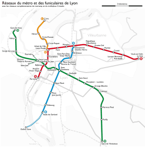
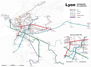
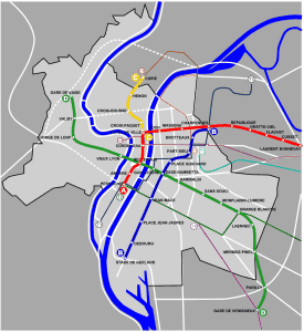
These are older Lyon metro maps that we posted here as a historical curiosity:


