The Rio de Janeiro metro, officially known as “Metrô do Rio de Janeiro” o “Metrô Rio“, It is the main underground transportation system of the city of Rio de Janeiro, Brazil.
Inaugurated on 5 March 1979, the system currently has two main lines, that together add up 41 stations over approximately 57 kilometres (35.4 miles) of roads.
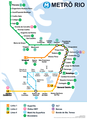
Below we show you the map of the Rio de Janeiro metro. Click on the image to see it larger:

In case you need it, we also have the Rio de Janeiro metro map in PDF format.
Personal use of the map is allowed, printing and distribution, but it is expressly prohibited to use it on another website or app.
Official Web site
- Visit the official website of the Rio de Janeiro metro: www.metrorio.com.br
- For those who plan to spend several days in the city and want to explore famous or unseen sites, take a look at This website is a great option to get ideas, even if you don't buy anything.
Rio de Janeiro metro schedules
- Weekdays and Saturdays: 5:00h a 0:00h
- Sundays and holidays: 7:00h a 23:00h
Rates
Next, The main fares of the Rio de Janeiro metro are presented in Brazilian reals (BRL) and its equivalent in US dollars (USD), so that tourists have a better idea of the price:
| Rate Type | Precio (BRL) | Precio (USD) |
|---|---|---|
| Unitary Ticket | 7.50 BRL | 1.55 USD |
| Tarifa Social | 5.00 BRL | 1.04 USD |
| Metrô + BRT | 9.05 BRL | 1.87 USD |
| Metrô + Ônibus Integração | 8.25 BRL | 1.71 USD |
| Metrô + Trem | 8.55 BRL | 1.77 USD |
| Metrô + Ônibus Intermunicipal | 8.55 BRL | 1.77 USD |
| Metrô + Barcas | 8.55 BRL | 1.77 USD |
| Metrô + Van Rocinha y Vidigal | 8.55 BRL | 1.77 USD |
Special Cards
Cartão Unitário / Giro: The Cartão Unitário It is ideal for sporadic trips. On the other hand, he Cartão Giro It is a rechargeable option that offers additional benefits such as credit security and discounts at various partner establishments. It is accepted in all metro stations and in the system Metrô Na Superfície.
Social Tariff: This rate is available for people with declared monthly income less than or equal to R$ 3,205.20, with ages between 5 y 64 years, and that they have the Bilhete Único Intermunicipal (BUI) registered and linked to your CPF. This benefit reduces the cost of the trip by R$ 7.50 a R$ 5.00.
Payment by approach: Users can pay directly at the counters with Visa credit/debit cards, Mastercard, Elo or mobile devices with NFC technology, without having to buy a physical ticket. This option is also available for the system Metrô Na Superfície.
Integrations
The transportation system in Rio de Janeiro allows fare integrations that facilitate transfers between different means of transportation with the same ticket, like buses, BRT, trains and boats, with combined rates that provide savings to frequent users.
History of the Rio de Janeiro metro
The first project for a metro in Rio de Janeiro arose in the years 1930. The idea was to alleviate traffic in the city center, especially with the electrification of trams, They could no longer meet the growing demand.

In 1966, was created Comisión Ejecutiva do Metropolitano do Rio de Janeiro (CEPE-2) to develop the metro project. This commission, directed by the General Milton Gonçalves, hired various companies to carry out feasibility studies.
The 14 December 1968, was founded Companhia do Metropolitano do Rio de Janeiro, although construction actually began in 1970 in Jardim da Glória. The works faced many difficulties, including lack of resources, which led to pauses in construction between 1971 y 1974. Finally, he 5 March 1979, the system was inaugurated with five stations: Praça Onze, Central, Presidente Vargas, Cinelândia y Glória.
The 80s′ y 90′
In 1980, The system began to expand with the opening of the stations Uruguaiana y Estácio, which increased passenger demand. Station Carioca, one of the busiest, opened in January 1981. later that year, the stations were completed Catete, Flamengo y Botafogo.
The line 2 The 19 November 1981, initially with three stations: São Cristóvão, Maracanã y Estácio. This line allowed a direct connection with the stadium Maracanã and the UERJ campus. The expansion continued in 1982 with the opening of the stations Afonso Pena, São Francisco Xavier y Saens Peña.
During the decade of 1980, innovations were introduced such as bilhetagem automatic and fare integration with other means of transport. The line 2 expanded in 1983 with the seasons Maria da Graça, Del Castilho, Inhaúma e Irajá. Nevertheless, Economic and technical problems affected the continued growth of the metro. For example, in 1985 an accident in Engenho da Rainha caused significant damage, paralyzing parts of the system.
In the years 90, The metro suffered from lack of investment and maintenance, what led to the “cannibalization” of trains to obtain parts. However, in 1998, The system was privatized and operated by the Opportrans Consortium under a concession of 20 years.
21st century and today
The line 4, that connects the Zona Sur with the Barra da Tijuca, was inaugurated on 30 June 2016, just before the Summer Olympics. This project, costing around R$ 8,5 billion, he added 16 kilometers of new tracks and five stations: Jardim Oceânico, São Conrado, Antero de Quental, Nossa Senhora da Paz y Jardim de Alah.
The last station inaugurated in the Rio de Janeiro metro is the Estação Jardim Oceânico, which is part of the Line 4. This station opened to the public on 30 June 2016, just before the Summer Olympics held in the city. The line 4 connect the station General Osório in Ipanema with Jardim Oceânico in Barra da Tijuca, passing through the neighborhoods of Ipanema, Leblon y São Conrado. This project added 16 kilometers to the metro network and was carried out with a significant investment, part of which was financed by the Rio Barra consortium, responsible for the works.
At the moment, no new immediate expansions planned, although there is a station under construction whose works are suspended for the moment.
History of the Rio de Janeiro metro map
The first version of the map of the year 1975 it had only five stations: Praça Onze, Central, Presidente Vargas, Cinelândia y Glória, covering a stretch of 4,3 kilometres. Since then, The map has grown to include 41 stations and approximately 57 kilometers of roads, distributed in three main lines.
In the early decades, The subway maps were designed mainly by engineers and architects linked to the Companhia do Metropolitano do Rio de Janeiro (MetroRio), created in 1968. Among the pioneers was the Comisión Ejecutiva do Metropolitano do Rio de Janeiro (CEPE-2), directed by the General Milton Gonçalves, who supervised the technical and economic feasibility studies of the system.
Map expansion occurred through several phases. In the years 80, important stations were added such as Carioca, Catete, Flamengo y Botafogo. Each map update required a detailed review to reflect these expansions and improve the readability and usability of the map for passengers..
In 1998, when the metro operation was privatized and passed into the hands of the Consórcio Opportrans, They focused on the modernization of the maps. This company, with a grant of 20 years, committed to improving the infrastructure and visual presentation of the routes. The maps began to include more details and were translated into English to serve tourists..
The line 4, inaugurated in 2016, represented a significant addition to the metro map, connecting the South Zone with Barra da Tijuca. This project involved the construction company Invepar and the international consulting firm CRRC, who helped design and execute this expansion. The inclusion of this line required a comprehensive update of the map to ensure that users understood the new routes and connections.
Additional data
The Rio de Janeiro metro has stations decorated with works of art. Besides, It is a quick route to reach some of the most iconic places in the city, like the stadium Maracaná, he Parque do Flamengo and Copacabana beach. We have made a list of the most important places in Rio de Janeiro and the closest metro stop:
- Christ redeemer (Cosme Velho, Line 1): monumental statue of 30 meters high, located at the top of Corcovado, offers panoramic views of Río de Janeiro.
- Pão de Açúcar (Botafogo, Line 1): mountain of 396 meters accessible by cable car, famous for its views of the bay Guanabara and the city skyline.
- Copacabana Beach (Cardeal Arcoverde, Line 1): Urban beach with a characteristic boardwalk, surrounded by hotels, bars and restaurants, famous for its events and festivities.
- Ipanema Beach (General Osório, Line 1): Beach recognized for its white sand and strong waves, located in an elegant neighborhood with shops, cafes and active nightlife.
- Botanical Garden (Jardim Botânico, Line 1): Park with more than 8,000 plant species, founded in 1808, includes an orchidarium and a Japanese garden.
- Museum of Tomorrow (Uruguaiana, Line 1): Futuristic building designed by Santiago Calatrava, focused on science and sustainability, located in the revitalized port.
- Estadio Maracanã (Maracanã, Line 2): One of the largest football stadiums in the world, World Cup final venue, offers tours of its facilities.
- Lagoa Rodrigo de Freitas (Lagoa, Line 1): Large lagoon surrounded by cycle paths and parks, Popular for water sports and outdoor recreation.
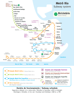
Old metro map of Rio de Janeiro
In historical mode, We hang the old subway maps in this section, Specifically, the following maps are from the year 2014:

