The Rome metro, officially known as “Metropolitana di Roma”, is the underground transportation system in the capital of Italy. Inaugurated on 10 February 1955, has grown over the years, with the latest extension in 2022.
The system consists of 3 lines that cover 73 stations along 60 kilometres (about 37.28 miles). It is essential for the daily mobility of residents and tourists visiting Rome..
Here's the Rome metro map. Click on the map to see it larger:
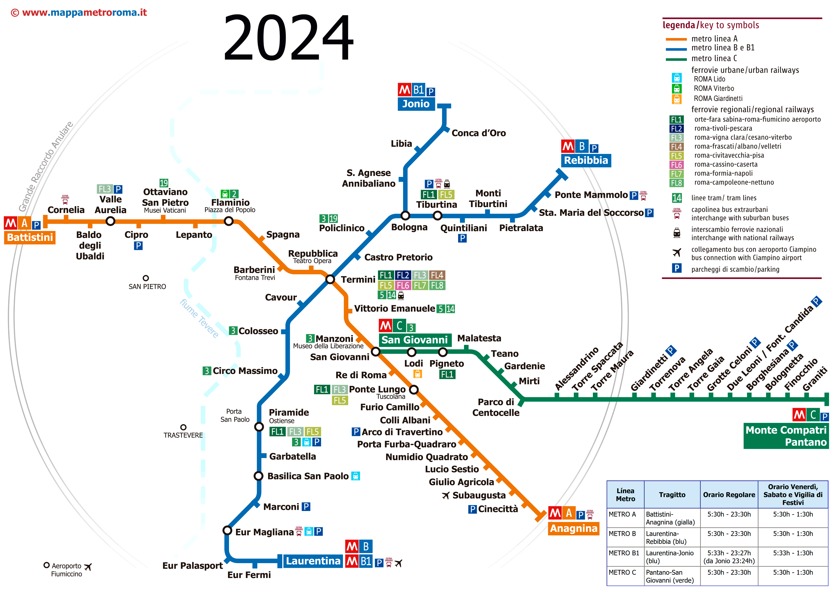
We've taken the map from mappametroroma.it We recommend visiting this website, since they update the map frequently.
Official Web site
For more information, you can visit these websites:
- Unofficial website of the Rome metro (better and easier to use).
- Official website of the Rome metro.
- Website with all the tourist attractions of Rome.
Rome metro timetables
The Roman metro operates with the following schedules:
| Day | Time |
|---|---|
| Work days | Of 5:30 until 23:30. |
| Fridays and Saturdays | Of 5:30 until 1:30 the next day. |
| Sundays and holidays | Of 5:30 until 23:30. |
Important: Of the 8 from April to 5 December 2024, Line A closes at 21:00 Sunday to Thursday, due to works. Fridays and Saturdays, They have their normal hours until 1:30 of the night.
Rates
The price of the tickets (year 2024) most used are the following:
| Type of ticket | Price in EUR | Precio USD (approx.) | Description |
|---|---|---|---|
| One-way ticket | 1.50 EUR | ~1.64 USD | a single trip |
| Roma 24H | 7 EUR | ~7.68 USD | Unlimited trips during 24 hours |
| Roma 48H | 12.50 EUR | ~13.71 USD | Unlimited trips during 48 hours |
| Rome 72H | 18 EUR | ~19.73 USD | Unlimited trips during 72 hours |
History of the subway

The first detailed project was proposed by the engineer Lorenzo Allievi in 1885, although before, Francesco degli Abbati had sketched ideas for an underground network.
However, These initial projects were not done due to various complications, including costs and geological risks. And the biggest problem was that the minimal work that was done, archaeological remains appeared.
We had to wait until 1941 to develop a more concrete plan, under the direction of the engineer Vito Perrone. It's plan, approved by the Ministry of Public Works, established the foundations for a metropolitan network that would include several main lines. Construction began before World War II, but they stopped because of the conflict. Some of the infrastructure already built, They were used as air raid shelters.
Finally, in 1955, the first section was inaugurated of what we know today as Line B, in the presence of the then President of the Republic, Luigi Einaudi. This initial section connected the station Termini with the EUR neighborhood, Designed for the Universal Exhibition in Rome 1942, which was not held due to World War II.
Line A was added in 1980, connecting strategic points from Ottaviano until Anagnina, and was later expanded to include the section up to Battistini in the year 2000.
XXI century
Line C, latest and technologically advanced, was inaugurated in 2014, and has been extended in successive phases.
Line B1, a branch of Line B, It was inaugurated in stages between 2012 y 2015.
The last metro station inaugurated in Rome is the station “San Giovanni” of Line C, in may 2018. This station forms an important interconnection node with Line A, significantly improving connectivity in the city's transportation network.
In the future
The construction and expansion of the Rome metro has been and continues to be very complicated, due to the immense amount of archaeological treasures still buried underground. But thanks to it, it has been possible to create the first “archaeological station” of the world, The San Giovanni, inaugurated on 12 May 2018.
And not only that, construction of an underground museum has already begun, 100 times bigger, near the station Piazza Venecia, and this “museum-subway station” It will be eight stories deep.
The project manager, Andrea Shoti, He made statements to CNN news: “It's true, 10 years seems like a long time, But we are not just dealing with engineering issues.. This Rome metro station will be considered the most beautiful in the world. We don't have to rely on items being brought in from the museum. The museum station is in its original context in ancient Rome.”
History of the Rome metro map
Curiously, specific details about the individual designers or design firms involved in the various stages of subway map development, are not widely documented or accessible in available sources. This may be because the creation of these maps is often considered part of the internal operations of public transport companies such as ATAC, that manages the metropolitan network.
Some time ago it appeared on a website that Italian designers and cartographers, as Roberto Di Laurentiis, participated in creating a clear visual representation of the map, but we have not found in what period.
Although no specific names of designers or companies are mentioned, It is evident that the design of the maps has been a collaborative task, possibly involving internal teams of Roberto Di Laurentiis with the support of external consultants in graphic design and urban planning. This is common in public transportation projects., using equipment that may not credit specific individuals.
Additional data
Rome's metro connects passengers to some of the city's most important tourist sites:
- Coliseum: Station “Colosseo” on Line B provides direct access to the famous Roman amphitheater.
- Vatican: Station “Ottaviano” on Line A is the entrance to St. Peter's Basilica and the Vatican Museums.
- Fontana di Trevi: Station “Barberini” on Line A leaves you just a few steps from this iconic fountain.
- Pantheon: Although it does not have its own station, station “Spagna” on Line A and the station “Barberini” are the closest points, allowing a walk through the historic center.
- Piazza di Spagna: Station “Spagna” on Line A is in the heart of this famous square, known for the “Spanish Steps”.