Osaka Municipal Subway (officially called 大阪市営地下鉄, Ōsaka-shiei Chikatetsu) It is a crucial urban transportation system in the city of Osaka, Japan.
Inaugurated on 20 May 1933, It is the second oldest subway in Japan, after the of Tokio. It consists of 8 lines and 133 stations covering a total length of 137.8 km (85.6 miles).
The system is operated by Osaka Metro Co., Ltd., which has modernized and expanded the network over the years to improve the accessibility and efficiency of transportation in the city.
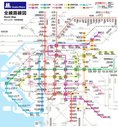
subway map
Below we show you the Osaka subway map:

Official Web site
- Isaka Subway Official Website: Osaka Metro.
- Website with all Osaka attractions and shows.
Schedules from the Osaka subway
- Every day: 5:00 – 0:00
Osaka Subway Fares
Osaka Subway fares vary depending on distance traveled. Next, A table is shown with the main prices and their equivalent in dollars, so that tourists can get an idea:
| Distance | Precio (JPY) | USD equivalent |
|---|---|---|
| 1-3 km | 180 JPY | 1.32 USD |
| 4-7 km | 230 JPY | 1.68 USD |
| 8-11 km | 280 JPY | 2.04 USD |
| 12-15 km | 330 JPY | 2.41 USD |
| 16-19 km | 380 JPY | 2.78 USD |
| 20-23 km | 430 JPY | 3.14 USD |
These basic fares cover single trips within the metro system..
Special Cards and Discounts
- ICOCA: This smart card allows users to travel without purchasing individual tickets and offers discounts for frequent travel. Besides, can be used in other transportation systems and associated businesses.
- Enjoy Eco Card: Ideal for tourists, This card allows unlimited travel for one day on all Osaka Metro lines and municipal buses. The price is 800 JPY (5.84 USD) during the week and 600 JPY (4.38 USD) weekends.
- Tarjetas de Commuter Pass: These cards offer unlimited travel between two specific stations for a set period (1, 3 o 6 months). Prices vary depending on the distance and the period selected. For example, a monthly pass for a short distance costs approx. 7,930 JPY (58 USD), while a pass for longer distances can cost up to 12,770 JPY (94 USD).
Osaka Subway History

The Osaka subway began its history on 20 May 1933 with the opening of the Midōsuji Line. This line, que conectaba Umeda con Shinsaibashi, It was the first public subway line in Japan. Its construction was led by engineer Minami Shigeo and financed by the Osaka municipal government..
In 1969, The Chūō Line was inaugurated, connecting Ōsakakō with Nagata. This line included the notable section under Osaka Harbor, completed with an underwater rail and road tunnel.
The expansion continued over the years 70 y 80 with the opening of several more lines. In 1970, Yotsubashi Line was inaugurated, extending from Nishi-Umeda to Suminoekoen. In 1981, The Sennichimae Line began operating between Nodahanshin and Minami-Tatsumi.
The decade of 90 saw the integration of the Nanko Port Town Line, which was inaugurated in 1981 and was completely integrated with the metro in 1997. In 1990, Osaka Monorail opened, offering additional connections across the city and its suburbs.
In the new millennium, The Imazatosuji Line opened on 24 December 2006, stretching from Imazato to Itakano. This line used linear motor trains, an advanced technology to improve energy efficiency and operation.
Finally, in 2018, the subway administration was reorganized, going from being a municipal entity to a private corporation, Osaka Metro Co., Ltd. This change sought to attract private investment and revitalize Osaka's economy..
Osaka Subway Map History
The Osaka subway map has evolved significantly since its beginnings in 1933, with the opening of the Midōsuji Line. This first map was designed to be simple, Conectando Umeda y Shinsaibashi, reflecting the modest extent of the network at the time. Over time, as more lines and stations were added, Map complexity increased considerably.
During the years 60 y 70, The design of the Osaka subway map was mainly managed by the planning department of the Osaka subway. Osaka Municipal Transportation Bureau. This period saw the incorporation of new lines such as Tanimachi and Yotsubashi., requiring redesigns to accommodate these expansions. The maps of this era were characterized by a functional approach, prioritizing clarity and ease of use for passengers.
In the decade of the 80, Japanese graphic design company Nippon Design Center (NDC) began to collaborate with Osaka Municipal Transportation Bureau to modernize the map. Under the direction of renowned designer Yoshiaki Irobe, More sophisticated visual elements were introduced, including color coding for lines and standardization of icons and typography.
The map continued to evolve with the incorporation of digital technology over the years 2000. Interactive electronic versions were introduced, accessible from mobile devices and metro stations. These versions were developed by Osaka Metro Co., Ltd., the entity that assumed management of the metro after privatization in 2018. The company also commissioned local design agencies to create more intuitive and accessible maps, adapting to the needs of a modern city.
Additional data
The Osaka subway is not only vital for daily transportation, but also connects important tourist and cultural destinations. Among them are these most famous tourist places in Osaka:
- Osaka Castle (Tanimachi 4-chome, Tanimachi/Chuo Line): Stunning historic castle, surrounded by a beautiful park, ideal for hanami in spring.
- Dotonbori (No, Midosuji Line): It is a major entertainment district, famous for its bright signs and delicious street food.
- Universal Studios Japan (Universal City, Yumesaki Line): Theme park with exciting attractions and the new Super Nintendo World.
- Umeda Sky Building (wet, Midosuji Line): Architectural icon with an observatory on the floor 39, offering panoramic views of Osaka.
- Shinsaibashi (Shinsaibashi, Midosuji Line): Main shopping area with luxury stores, shops and restaurants.
- Osaka Aquarium Kaiyukan (The hunters, Chuo Line): One of the largest aquariums in the world, Known for its impressive central tank.
- Tsutenkaku Tower (Ebisucho, Sakaisuji Line): Iconic tower in the Shinsekai area, offers a stunning view and a nostalgic atmosphere.
- Abeno Harukas (Tennoji, Midosuji Line): The tallest building in Japan, with an observation deck that provides spectacular views.