The Lille metro system, officially known as “métro de Lille” in French, is located in Lille, France. It opened 25 April 1983 and currently has two lines that cover 62 stations, with a total length of 45.5 km (about 28.27 miles).
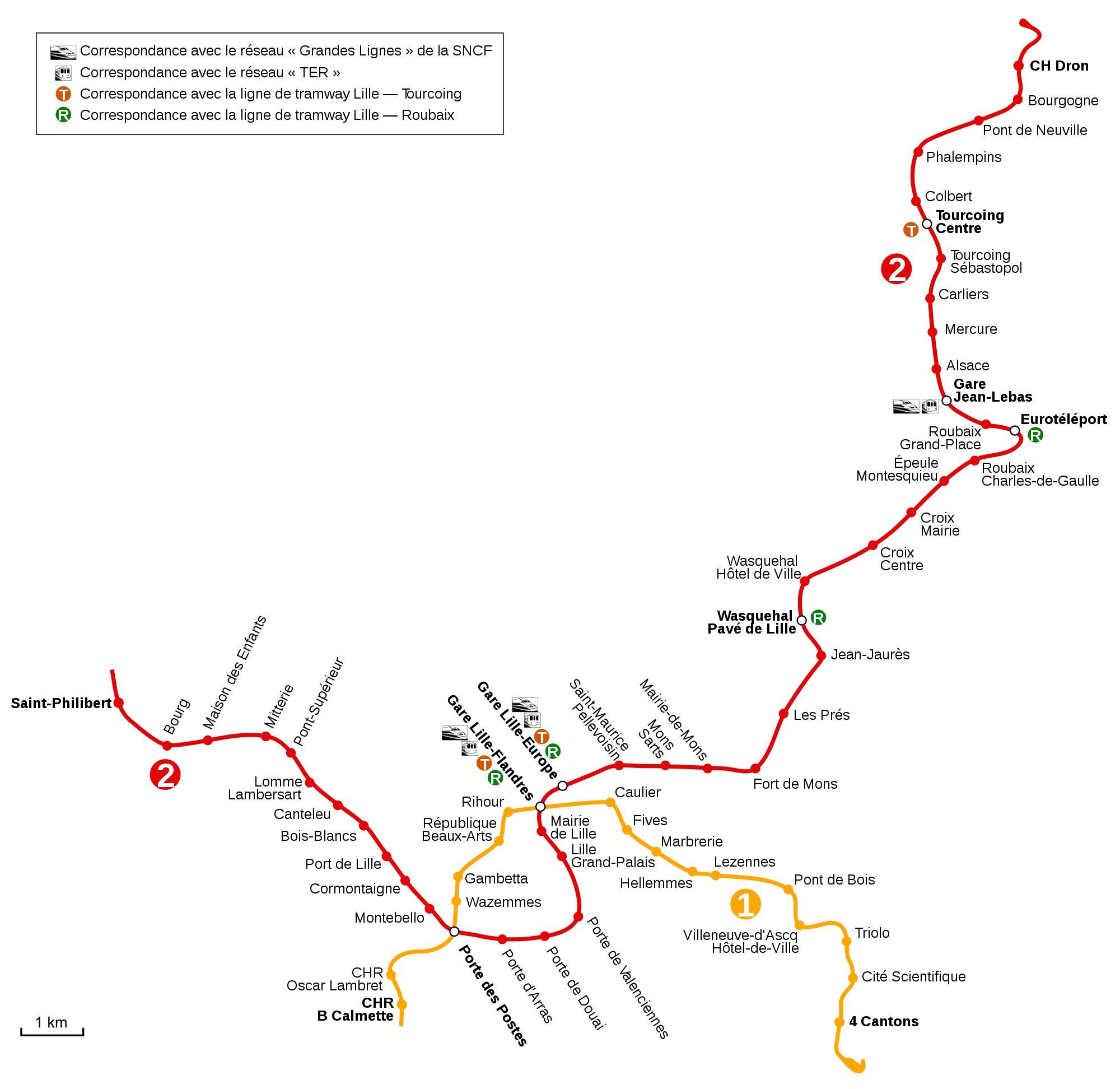
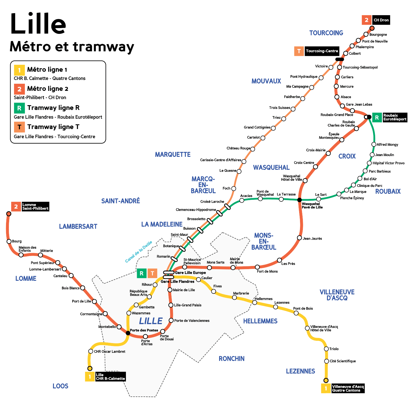
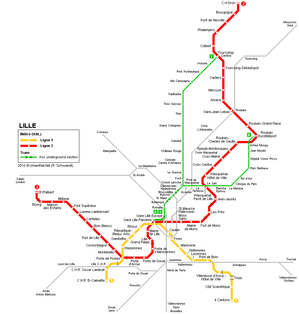
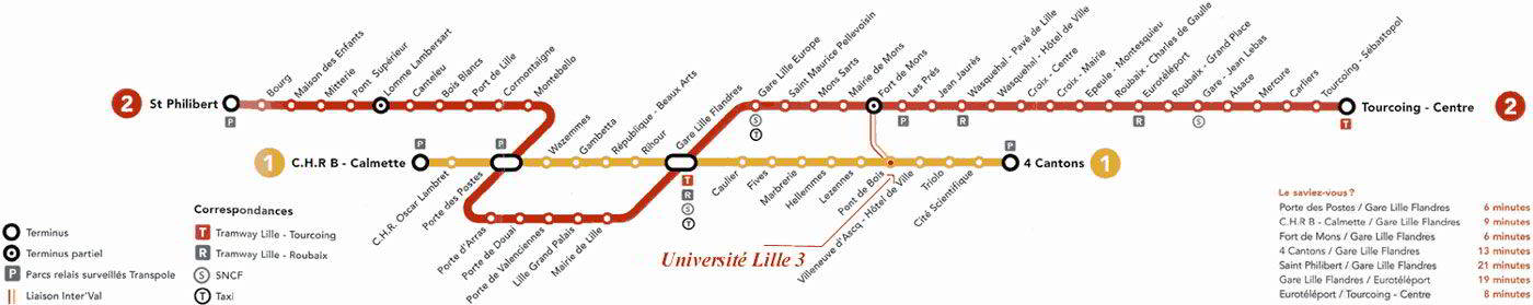
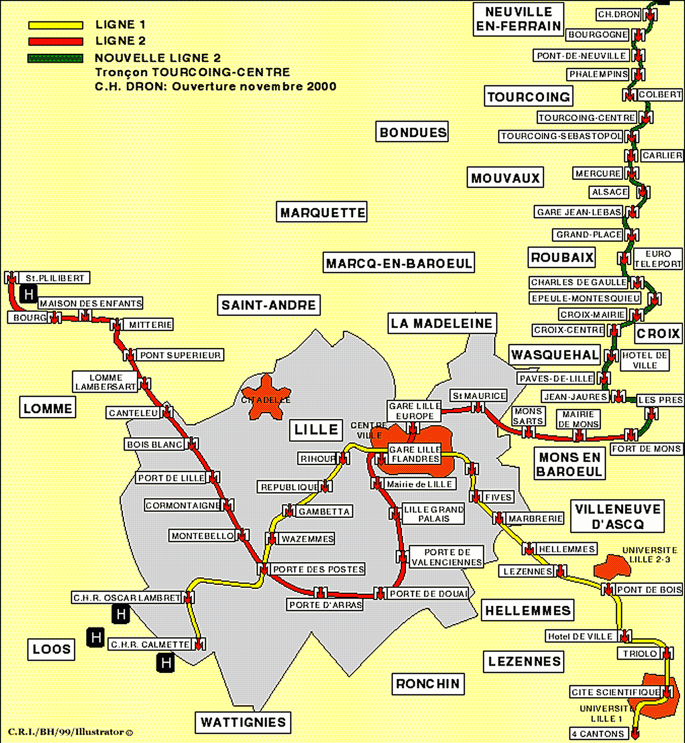
Here's the Lille metro and tram map. Click on the image to see it larger:

We also have the Lille metro and tram map in PDF.
This map of the metro and tram of Lille is derived from ‘Plan du métro et tramway de Lille‘ by Mortadelo2005, under the license CC BY-SA 4.0. Access the original version here.
Schedules
- Weekdays and Saturdays: 5:00h a 0:30h
- Sundays and holidays: 6:00h a 0:30h
Rates
The Lille Metro Fare System, is managed by the company Ilévia. Here is a table with the main prices in euros, and with its equivalent in US dollars (so that tourists get a better idea of the price):
| Type of ticket | Precio (EUR) | Precio (USD) |
|---|---|---|
| One-way ticket | 1.80 | 1.98 |
| Ticket Zap (3 Interstations) | 1.15 | 1.27 |
| Notebook of 10 tickets | 15.40 | 16.94 |
| daily pass (Unlimited Transportation) | 5.30 | 5.83 |
| Weekly Pass | 15.00 | 16.50 |
| Monthly pass | 54.00 | 59.40 |
| Annual Pass | 540.00 | 594.00 |
Besides, Ilévia Offers various types of cards and special discounts:
- Carte Pass Pass: A rechargeable card that allows users to use the metro, Buses and trams with a single support. Available in custom and anonymous versions.
- Youth Card: Discounts for young people between 4 y 25 years.
- Senior Card: Special offers for seniors 65 years.
- Tourist Pass: Visitor options including unlimited transportation for a day or more.
- Work subscriptions: Reduced fares for workers within the metropolitan area.
Official Web site
- For more information, visit the official website: www.ilevia.fr
History of the Lille Metro
The history of the Lille metro, known as VAL (Véhicule Automatique Léger), started in the years 1960. Congestion in the centre of Lille and the lack of efficient transport in the suburbs prompted the idea of decentralisation and the creation of a new city, Villeneuve-d’Ascq.
In 1968, The Établissement Public d’Aménagement de Lille-Est (EPALE), in charge of the development of this new city. The VAL technology was developed at the University of Science and Technology of Lille, under the direction of the teacher Robert Gabillard. Matra, The winning company of the tender for the construction of the metro, used this innovative technology.
Work began in 1977. In 1983, the line 1 was inaugurated, Connecting Quatre Cantons a Villeneuve-d’Ascq with the centre of Lille. François Mitterrand, President of France, attended the opening ceremony on 25 April 1983. This event marked the opening of the world's first automatic metro, A technological milestone.
The line 2, Initially called the line 1 encore, began to operate in 1989. This line connects Saint-Philibert con CH Dron, via Lille, Roubaix and Tourcoing. The construction of this line was completed in 2000, Extending the Metro's Range Even Further.
The original project contemplated four lines. However, due to high costs, only two were built. The lines 3 y 4 were replaced by a high-capacity bus system. In 1989, The Operating Company, Compagnie du Métro de Lille, merged to form Transpole, and in 2019, It was renamed Ilévia, that currently manages the metro.
As the latest news, The last station inaugurated in the Lille metro was “Saint-Philibert” On the line 2, he 18 August 1999. And in the year 2018 incorporated 4G coverage throughout the line 1.
History of the Lille metro map
The creation of the first map dates back to the 1990s. 1970, when the development of the system began VAL (Véhicule Automatique Léger). Robert Gabillard, professor at the University of Sciences and Technologies of Lille, played a crucial role in the development of the VAL and in the planning of the metro system.
The design of the original map was made in conjunction with the company Matra, that won the tender for the construction of the metro. Matra, Known for its experience in the aeronautical sector, applied its advanced engineering knowledge to develop an efficient and reliable system. Bernard Guilleminot, a young engineer from 29 years, He led the construction of the subway and oversaw early versions of the map.
The first subway map, created for the inauguration in 1983, showed only the line 1, that connected Quatre Cantons in Villeneuve-d’Ascq with the centre of Lille. This map was designed taking into account the connections of the main stations and the connection points with other modes of transport, like buses and trams.
In 1989, with the opening of the line 2, The map was updated to include this new route, which extended the service from Lomme until Roubaix y Tourcoing. The incorporation of the line 2 required significant redesign to maintain map clarity and functionality. This upgrade work was carried out by the engineers and designers of Matra, in partnership with the urban community of Lille (CUDL).
XXI century
In 2019, Ilévia took over the management of the Lille metro and presented new versions of the maps, Designed with a modern approach and increased accessibility in mind. These updated maps highlight useful details, such as interconnections with the high-capacity bus system and comprehensive 4G coverage on the line 1.
Regarding the resources available online, There is a variety of opinions. While some users prefer official maps, others find great value in the alternate versions created by the community, such as those elaborated by the author Mortadelo2005, which are based on the maps available on Wikipedia.
Additional data
The Lille metro connects important tourist and economic hotspots. Besides, All transport is integrated both metro and buses and trams, Facilitates mobility throughout the metropolitan area.
These are the top tourist attractions in Lille, and the nearest metro stop:
- Grand Place (Metro stop: Rihour, line 1): Historic center with emblematic buildings and vibrant atmosphere.
- Palais des Beaux-Arts (Metro stop: République – Beaux-Arts, line 1): Art museum with a vast European collection.
- Beffroi de l’Hôtel de Ville (Metro stop: Mairie de Lille, line 2): Tower of 104 meters with panoramic views of the city.
- La Citadelle (Metro stop: Cormontaigne, line 2): Seventeenth-century fortress surrounded by a leafy park.
- Vieux Lille (Metro stop: Gare Lille Flandres, lines 1 y 2): Historic neighborhood with cobblestone streets, Shops and restaurants.
- Marché de Wazemmes (Metro stop: Gambetta, line 1): Vibrant market with local products and textiles.
- Hospice Comtesse (Metro stop: Rihour, line 1): Former medieval hospital now converted into a museum.
- Gare Saint-Sauveur (Metro stop: Lille Grand Palais, line 2): Old train station converted into a cultural space with exhibitions and events.
Old Lille metro maps
In historical mode, in this section will be hung the old maps of the metro and tram of Lille. At the moment they are all year-round 2014 or previous: