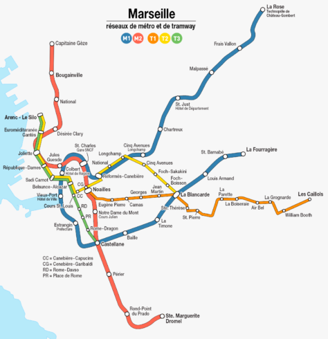
The Marseille metro, locally known as “Métro de Marseille“, is the underground transport system of the city of Marseille, France.
Inaugurated in 1977, the metro has 2 lines (M1 y M2) y 29 stations in total. The net has a total length of 22,7 kilometres (14,1 miles).
subway map
Below is the map of the Marseille metro:

We also have a version of Marseille metro map in PDF.
Official Web site
- This is the official website: RTM – Régie des Transports Métropolitains
- And here you can see all Marseille attractions and tourist sites.
Marseille metro timetable
| Line | Days | Time |
|---|---|---|
| Line 1 (La Rose – La Fourragère) | Monday to Friday | 5:00 – 1:00 |
| Saturdays | 5:00 – 1:00 | |
| Sundays and holidays | 6:00 – 1:00 | |
| Line 2 (Bougainville – Sainte-Marguerite Dromel) | Monday to Friday | 5:00 – 1:00 |
| Saturdays | 5:00 – 1:00 | |
| Sundays and holidays | 6:00 – 1:00 |
Rates
The Marseille metro offers a variety of fares and passes designed to meet the needs of different types of users. Next, The main ticket prices in euros are presented (EUR) and its equivalent in US dollars (USD):
| Type of ticket | Precio (EUR) | Precio (USD) |
|---|---|---|
| One-way ticket | 2,00 € | 2,20 USD |
| daily pass | 5,20 € | 5,80 USD |
| Weekly Pass | 14,10 € | 15,80 USD |
| Monthly pass | 49,00 € | 54,90 USD |
In addition to these standard tickets, There are several special cards and passes that offer discounts and additional benefits:
- Pass Permanent Jeune Solidarité: This pass is available to young people up to 25 years and allows unlimited rides for one month per 9,20 € (about 10,30 USD).
- Pass Permanent Métropole: For people over 26 years, This pass offers unlimited travel for 30 € per month (about 33,60 USD) and is aimed at beneficiaries of the Solidarité Complémentaire Santé.
- Pass 30 jours Scolaire Solidarité: Designed for students and young people of 11 a 25 years, This pass costs 24,70 € per month (about 27,60 USD) and allows unlimited travel on all bus lines, Marseille metro and tram.
- Pass touristique culturel: This pass is aimed at tourists and allows access to multiple cultural attractions in addition to the use of public transport. Prices and specific details vary depending on the length and inclusions of the pass.
History of the subway

The history of the Marseille metro begins with proposals before and after World War II. Initially, it was considered to modernize the existing trams, but the lack of materials and the destruction caused by the war resulted in the almost complete elimination of the tram system.
In the decade of 1960, The growth in car use caused serious congestion in the city. In 1964, A project to build an underground metro line finally caught the attention of local authorities, and in 1969, The municipal council voted unanimously in favor of the creation of the metro system.
The construction of the Line 1 (M1) of the subway began 13 of August of 1973.
Start of the subway
Finally the first line was partially opened on 26 November 1977, Connecting La Rose con Saint-Charles. The complete line was inaugurated on 11 March 1978.
Planning for the Line 2 (M2) started in 1978, and its construction began in 1980. The central portion of this line, in between Joliette y Castellane, The 3 March 1984. The north and south extensions of the line were completed in February 1986 and February 1987 respectively.
The Marseille metro continued to expand. In 1992, the line 1 extended from Castellane until La Timone, and in 2010, it was extended again to La Fourragère. In December 2019, the line 2 spread north from Bougainville until Gèze.
Currently
In 2016, a ten-year modernization project for the metro began, which included the implementation of a communications-based train control system (CBTC) and upgrading infrastructure to enable driverless train operations. These new trains began to operate in semi-automatic mode at the beginning of 2024, and are expected to operate fully automated by 2027.
The construction of the subway and its expansions have been supervised and carried out by several companies, including CIMT and MTE under the direction of the Société Générale de Travaux et d’Etudes (SGTE). The local company Urban Community Marseilles Provence Metropolis (CUMPM) manages the operation of the metro.
History of the Marseille metro map
The development of the Marseille metro map has been an evolutionary process, reflecting transportation system expansions and modernizations. The first subway maps, designed in the years 70, They were simple, showing the first stations and basic routes.
Initially, The map was created by the engineers of the Régie des Transports de Marseille (RTM), in collaboration with local graphic designers. With the inauguration of the Line 1 in 1977 and the line 2 in 1984, The maps were updated to include the new stations and connections.
During the following decades, Several updates and redesigns were made. In the years 90, with the extension of the Line 1 towards La Timone and later towards La Fourragère, the map became more complex. Designers included additional details to improve user navigation.
In 2016, an ambitious metro modernization project began. This included not only the updating of trains and infrastructure, but also a significant redesign of the map. Ora Ito, A renowned French designer, He was hired to modernize the appearance of the map, making it more intuitive and visually appealing.
Additional data
Marseille is home to iconic sites such as the Basilica of Notre-Dame de la Garde and the Old Port. The metro makes it easy to access these and other tourist sites.
Besides, Marseille is known for its multiculturalism and Provençal cuisine. The metro network doesn't just serve residents, but it is also crucial for tourism, Easily connecting the main attractions.
- Vieux-Port (Vieux-Port – Hôtel de Ville, Line 1): The tourist heart of Marseille. Ideal for walks and enjoying a good bouillabaisse.
- Basilique Notre-Dame de la Garde (Estrangin – Préfecture, Line 1): It offers panoramic views of the city. Iconic symbol of Marseille.
- Le Panier (Joliette, Line 2): The oldest neighborhood, Full of history, Street art and quaint boutiques.
- MuCEM (Joliette, Line 2): Museum of European and Mediterranean Civilizations. Modern architecture and fascinating exhibitions.
- La Canebière (Noailles, Line 2): The most famous avenue in Marseille, full of shops and historic buildings.
- Palais Longchamp (Cinq Avenues – Longchamp, Line 1): Impressive palace and gardens housing art and natural history museums.
- Cathédrale de la Major (Joliette, Line 2): Large Roman-Byzantine style cathedral near the port. Impressive architecture .
- Parc Borély (Rond-Point du Prado, Line 2): Extensive park with botanical gardens and a lake. Perfect to relax.
Old subway maps
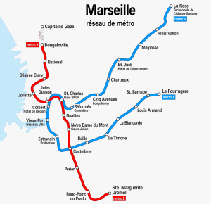
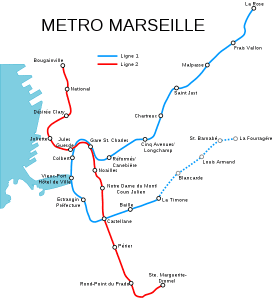
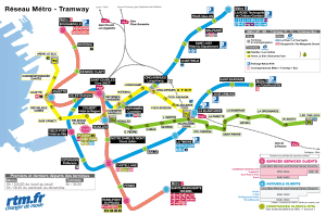
Below we show old maps of the Marseille metro map, to have them at a historical level. Click on the subway map below, to view larger image:


