The Bay Area Rapid Transit (BART) is the subway system that serves San Francisco and its surrounding areas in the state of California, EE.UU. Inaugurated on 11 September 1972, BART has grown to become an essential part of public transportation in the San Francisco Bay Area.
With a total of 6 lines and 50 stations, The system extends 197.8 kilometres (122.9 miles), connecting San Francisco with neighboring cities like Oakland, Berkeley, and Saint Joseph.
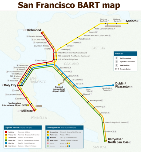
subway map
Below we show you the San Francisco subway map:

We also have the PDF version of the San Francisco subway map.
San Francisco subway schedules
- Work days: 4:00 AM until 12:00 AM
- Saturdays: 6:00 AM until 12:00 AM
- Sundays: 8:00 AM until 12:00 AM
Official Web site
- This is the official website from the San Francisco subway: Bart.gov
- This is the web with all attractions and San Francisco shows, with the possibility of purchasing tickets with discounts.
Rates
BART's fare system is based on trip distance and offers different prices for various zones and ticket types.:
- Adult ticket: $2.50 – $4.95 USD.
- Ticket for seniors (65+), disabled and young (5-18 years): 62.5% discount on regular rate.
- Clippers Cards: Reloadable payment card offering low rates and convenience.
Besides, There are monthly rate options and special passes for frequent travelers, as well as additional fees for parking at BART stations.
To calculate the exact cost of a trip, Passengers can use the BART fare calculator.
Rate Summary
- short trips (less than 6 miles): About $2.50 USD.
- Medium distance trips (6-14 miles): About $3.25 – $4.00 USD.
- Long trips (more of 14 miles): Until $4.95 USD.
Rates may vary slightly due to periodic adjustments and special rates for specific events or situations. It is advisable to always check the official BART website for updated fares.
History of the San Francisco subway: BART

El Bay Area Rapid Transit (BART) It is an engineering masterpiece and a testament to long-term collaboration in the San Francisco Bay region.. Its history dates back to the decade of 1940 and covers various planning phases, construction and expansion.
Origins and initial planning
The idea of BART arose in 1946 during informal meetings between business and civic leaders seeking solutions to growing traffic congestion on the San Francisco Bay Bridges. In 1951, The California State Legislature created the San Francisco Bay Area Rapid Transit Commission, what in 1957 recommended a high-speed electric train system to connect major cities around the bay.
Start of the project
Official construction of BART began on 19 June 1964, with President Lyndon Johnson inaugurating the work of the Diablo Test Track between Concord and Walnut Creek. This test section of 4.4 miles was completed in ten months and served to develop and evaluate new design concepts for the cars and the automatic train control system..
Construction phases
- 1966: Oakland Subway Tunnel Construction Begins. In November of the same year, work on the tube began transbay, connecting Oakland and San Francisco under the bay. This tube, Completed in 1969, It was the longest and deepest submerged tunnel in the world at the time..
- 1967: Completion of the Berkeley Hills Tunnel, a tunnel of 3.2 miles through hard rock and active faults.
- 1972: Inauguration of passenger service 11 of September, initially between Oakland and Fremont, con 28 miles of tracks and 12 stations.
- 1974: Start of transbay service between Oakland and San Francisco, restoring transbay passenger rail service for the first time since the discontinuation of the Key system on the Bay Bridge.
Later expansions
- 1995-1996: Extension from Concord to Pittsburg/Bay Point, with the eBART line beginning service in 2018.
- 2003: Opening of the line that connects with the San Francisco International Airport (SFO).
- 2014: Construction begins on extension to Warm Springs/South Fremont, which was inaugurated in 2017.
Engineering and companies involved
The BART project was managed by the joint venture Parsons-Brinckerhoff-Tudor-Bechtel (PB-T-B), which included Parsons Brinckerhoff, Tudor Engineering Company y Bechtel Corporation. These firms provided engineering specialists and managed all technical and construction aspects of the project..
Technological innovations
BART introduced several innovations, such as the use of lightweight aluminum wagons and a track width of 5 pies 6 inches, unusual in the United States, to improve stability and comfort. The system uses a power supply of 1,000 volts of direct current through a third rail, a design uncommon in other contemporary metro systems.
History of the San Francisco Subway Map: BART
The BART system map has gone through several significant transformations since its creation, reflecting the evolution and expansion of San Francisco's rapid transit system.
Next, A detailed chronicle of its development and the key designers involved in each stage is presented..
The first maps
The first subway map of San Francisco (BART) was designed in the years 70 When the system was inaugurated in 1972. This initial map, with dark blue waters and a single orange line, is an anonymous work of the engineers involved in the BART construction project.
These designers were likely from the engineering firms involved in creating BART., as Parsons Brinckerhoff, Tudor Engineering Company y Bechtel Corporation.
Evolution of the map over the years 90
In the years 90, Bart Wright, a professional designer and mapping expert from the Bay Area, started working on the BART map. Wright joined the Reineck firm & Reineck fresh out of college, and one of his first projects was updating the BART map. This was one of the first projects to fully use the computer for design..
Map modernization
Around the 2010/2011, Wright designed an improved version of the BART map that not only shows the BART system, but also other public transport connections, such as San Francisco Muni and the Santa Clara Valley Transportation Authority. Reineck & Reineck has continued to work directly with BART to iterate on the map, adding stations and transfers as needed.
Design philosophy
Wright emphasizes the need for the map to be easy to read and understand, especially for passengers who are standing in a crowded train, looking over someone else's shoulder to find out where to transfer. For this, a hierarchy of characteristics was determined, highlighting the seasons first, then the lines, The transfers, connections with airports, and the parking lots.
Controversies and challenges
Map design can be a contentious topic. For example, the famous modernist subway map designer, Massimo Vignelli, faced criticism when he designed a map for the New York subway in 1972. Wright, for his part, has had to ensure that the color scheme and the inclusion of certain geographical features make navigation easy for users, distinguishing the BART map from other public transportation maps.
Future of the BART map
With BART's continued expansion, especially towards San José, Wright has mentioned that it might be a good time to rethink the iconic map. The need to include new lines and stations suggests that the current map could be reaching the end of its useful life and require a complete overhaul to accommodate future expansions..
Most important tourist places in San Francisco
- Golden Gate Bridge (Stop: Jetty, Line: Blue) Icon of St. Francis, Famous Red Bridge Suspended Over the Bay.
- Alcatraz Island (Stop: Jetty, Line: Blue) Historic prison on an island, known for its famous recluses and escapes.
- Fisherman's Wharf (Stop: Jetty, Line: Blue) Popular seaside area with fresh seafood, Shops and the wax museum.
- Chinatown (Stop: Montgomery, Line: Yellow) The Largest Chinatown Outside Asia, full of shops and restaurants.
- Union Square (Stop: Powell Street, Line: Yellow) Main shopping district and hotels, with outdoor events.
- Golden Gate Park (Stop: Jetty, Line: Blue, and then bus) Sprawling urban park with gardens, museums and trails to explore.
- Pier 39 (Stop: Jetty, Line: Blue) Shopping and entertainment center with views of sea lions and the bay.