The “metro” of Bonn, locally known as “Stadtbahn Bonn“, is an urban transport system that extends throughout the city of Bonn, in Germany.
At the moment, the system has 4 main lines that run a total of 125 kilometres (77.7 miles), and serves 64 stations, some of which are underground, while others are surface. Its last extension was in December of the year 2011.
Say “metro de Bonn” It is not completely accurate because “metro” generally refers to a high-capacity urban subway train system, which does not adequately describe the Stadtbahn Bonn. Although some parts of Stadtbahn they are underground, It is primarily a light rail system. Therefore the most correct thing is to say “Bonn light rail”.
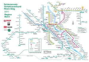
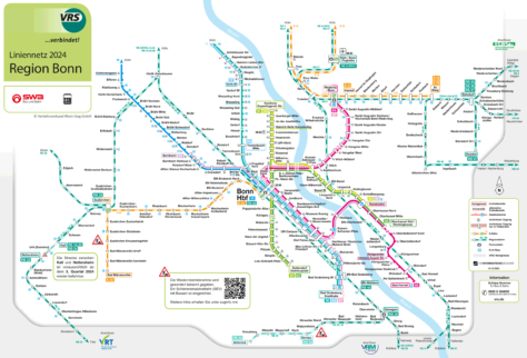
light rail map
Below we show you the Bonn light rail map in two different versions. Click on the image to see it larger:
Version of the previous map in PDF.
And the second version of the map:
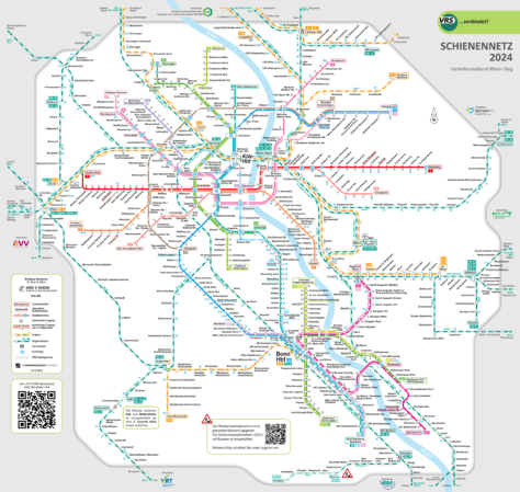
We also have the PDF version of the map.
Official Web site
- For more information and updates, visit the official website: Bonn light rail.
Bonn light rail timetable
The Stadtbahn Bonn operates with extensive hours to satisfy the needs of all its users:
- Work days: of 5:00 a 0:30
- Weekends: of 6:00 a 1:00
- Festive: of 7:00 a 0:00
Rates
The tariff system of Stadtbahn Bonn It is quite spacious and offers several options. Next, A table is presented with the main prices in euros and their equivalent in US dollars (so that tourists get a better idea of the prices):
| Type of ticket | Price in EUR | Price in USD (approx.) |
|---|---|---|
| One-way ticket | 3,00 EUR | 3,30 USD |
| daily ticket | 9,20 EUR | 10,10 USD |
| weekly ticket | 27,00 EUR | 29,60 USD |
| Monthly ticket | 95,00 EUR | 104,10 USD |
Cards and Discounts
In addition to regular tickets, he Stadtbahn Bonn offers several cards and options with special discounts:
- Germany ticket: A nationwide monthly ticket that costs 49 EUR (about 53,70 USD). This ticket allows unlimited use of public transport throughout Germany for one month.
- JobTicket: Designed for employees, This ticket is offered by companies to their workers at a reduced price. Provides unlimited rides throughout the month.
- HotelTicket: Available to tourists staying at participating hotels. This ticket allows unlimited use of public transportation during the visitor's stay..
- AzubiTicket: A discounted monthly ticket for apprentices and vocational training students. This ticket facilitates unlimited travel within the region at a very affordable price..
History of the Bonn metro
The history of the Stadtbahn Bonn begins in the decade of 1960, when local authorities saw the need to improve urban transportation. At the time, Bonn had several tram and light rail lines, operated by different companies, as the Bundesbahn (DB), the Köln-Bonner Eisenbahn (KBE), and other tram companies that covered urban and suburban routes.

The 22 March 1975, the first line of the Stadtbahn Bonn, which connected the center of Bonn with Bad Godesberg. This initial line was built using both underground and surface sections..
The development of Stadtbahn continued with the extension of the line 16, also known as the Rheinuferbahn, which began operating 12 of August of 1978. This line is particularly notable because it connects Bonn with Cologne, facilitating a constant flow of passengers between these two important cities.
The 80's′ y 90′
In the decade of 1980, major expansion projects were carried out. In 1989, The construction of the tunnel began in Bad Godesberg, an ambitious work that was completed in 1994. This tunnel, It was mainly built by underground mining methods. The official opening of the tunnel took place on 23 September 1994, and the resulting line included new underground stations in Wurzerstraße, Plittersdorfer Straße, Bad Godesberg Bahnhof y Stadthalle.
Besides, in 1987, a major reorganization of the lines was carried out. The U3 line became the line 63 and the line S on the line 66, thus optimizing the service and improving connectivity within the metropolitan area. In 1995, Bonn joined the Verkehrsverbund Rhein-Sieg (VRS), a transportation consortium that improved coordination between different forms of public transportation in the region.
The decade of 2000 brought more modernizations and improvements. In 2008, More efficient and ecological trains were introduced, reflecting Bonn's commitment to sustainability and innovation in transportation.
Current and future
The last station opened in the Stadtbahn Bonn It is the Olof-Palme-Allee station. This station opened its doors on 12 December 2011, thus extending the service on the line 66 and improving connectivity in the area.
Looking to the future there is an outstanding project, the new line that will connect Bonn with Niederkassel and Cologne. This project involves collaboration between Stadtwerke Bonn (SWB), he Verkehrsverbund Rhein-Sieg (VRS) and other local and regional entities. The extension will include the construction of new stations and the modernization of existing infrastructure, with a total length of approximately 21,3 kilometres.
History of the Bonn metro map
The first official map of Stadtbahn Bonn appeared in 1975, coinciding with the inauguration of the first line of the light rail system. This initial phase was marked by collaboration between the Stadtwerke Bonn (SWB) and the Kölner Verkehrs-Betriebe (KVB), reflecting an essential integration between the Bonn and Cologne systems.
During the years 80, the design of the map Stadtbahn was significantly influenced by the development of the tunnel Bad Godesberg. This project, that started in 1988 and was completed in 1994, It was managed by SWB engineers together with urban infrastructure consultants. The complexity of the project required detailed planning and accurate representation on maps for users., highlighting the new underground stations and modified routes.
XXI century
In the decade of 2000, the modernization of the map Stadtbahn included the incorporation of new design technologies.
The map design not only focused on functionality but also aesthetics and visual clarity. Graphic designers worked closely with transportation engineers to make sure the maps were easier to understand.
Currently
Currently, the design and updating of the map Stadtbahn Bonn, known as the Bonn light rail, It is mainly managed by Stadtwerke Bonn (SWB). This company not only operates the transportation system, It is also responsible for creating and maintaining maps of the light rail network and other public transportation lines..
Besides, SWB works closely with transportation and design experts to ensure maps are clear and functional for all users. The coordination and planning of the transportation system in the region of the Rhein-Sieg also involves Verkehrsverbund Rhein-Sieg (VRS), which works together with SWB to maintain and update transportation maps and services.
Additional data
The line 16, which connects the city of Bonn with the neighboring city of Cologne, is particularly notable, since it facilitates movement between these two important German cities. Besides, the network extends to Bad Godesberg, another significant point within the urban area of Bonn.
The Stadtbahn Bonn connects with the culturally important points of the city. When traveling in the Stadtbahn, Passengers can enjoy views of landmarks such as Beethoven House, he Kunstmuseum Bonn and the impressive Rheinische Friedrich-Wilhelms-Universität Bonn. Besides, the line 66, known as the “Beethoven Line”, takes passengers through beautiful landscapes to Siegburg, a trip that many consider a tourist experience in itself.
These are the best places to visit, and the stations to arrive:
- Beethoven-Haus (Bertha-von-Suttner-Platz, Line 66): Beethoven's birthplace, now a museum with the largest Beethoven collection in the world.
- Altes Rathaus (Bertha-von-Suttner-Platz, Line 66): Rococo building in the central market, used for official ceremonies and weddings.
- Poppelsdorfer Schloss (Poppelsdorfer Allee, Line 61): Baroque palace with botanical gardens, a green oasis in the city.
- Bonner Münster (Stadthaus, Line 62): Bonn main church, an impressive Romanesque basilica from the 11th century.
- Haus der Geschichte (Heussallee/Museumsmeile, Line 16): Museum that tells German history from 1945 until today.
- Rheinaue (Rheinaue, Line 66): Huge urban park ideal for picnics, boat rides and festivals.
- Alter Zoll (Universität/Markt, Line 66): Old fortification with panoramic views of the Rhine River and the surrounding area.
- Sterntor (Bertha-von-Suttner-Platz, Line 66): Rest of Bonn's medieval wall, evoking the history of the city.
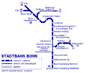
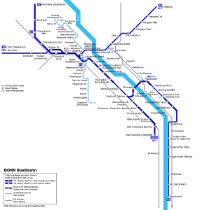
Old Bonn subway maps
In historical mode, We are publishing in this section the old Bonn metro maps, in this case they are from the year 2014 and previous years. Click on the following maps Metro, to see larger images:
The previous map, you can download in PDF format:
Download map-meter-bonn.pdf
