Tehran metro (“متروی تهران” in Persian) is the underground transportation system that serves the city of Tehran, the capital of Iran, and its metropolitan area. It is managed by the Tehran and Suburbs Metro Company (Tehran Urban & Suburban Railway Operation Company).
Con 7 lines in operation, The system has more than 250 kilometres (about 155 miles) of roads and 145 stations. Inaugurated in 1999, The subway has grown rapidly to become a vital artery for the city's urban mobility, with a network that covers the city and suburbs, providing efficient and fast connections.
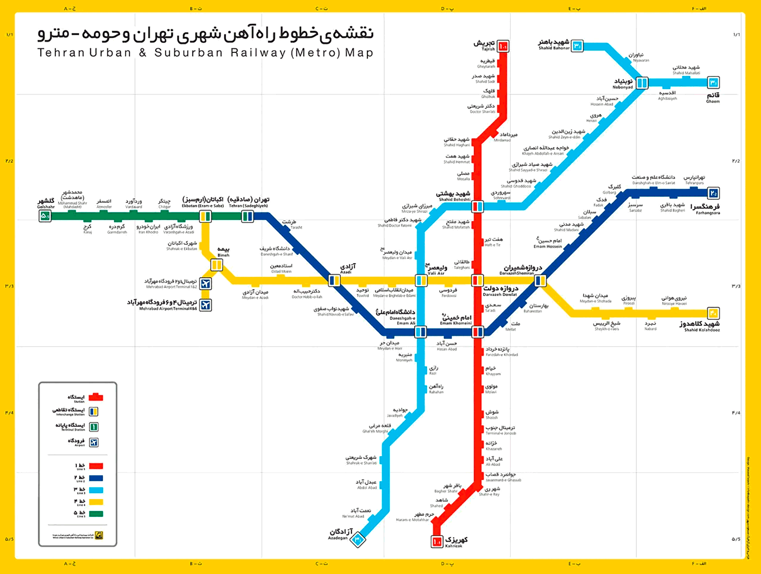
subway map
Here's the tehran metro map:
Tehran metro schedules
Tehran metro operates on a stable schedule, ensuring its availability for travelers:
- Every day: from 05:30 until 23:00
The frequency of train passage varies between 5 y 10 minutes, depending on the line and time of day.
Rates
The Tehran metro fare system is affordable and structured based on distances traveled. Prices in Iranian rials are:
- One-way ticket: 10,000 IRR (~0.24 USD)
- Card of 10 trips: 80,000 IRR (~1.92 USD)
Students and other eligible categories can access reduced rates.
Official Web site
For more information, visit Tehran Metro official website: metro.tehran.ir.
History of the Tehran Metro
Initial planning for the Tehran Metro began in 1970, led by Planning and Budget Organization and Tehran Municipality. The French company SOFRETU, linked to the Paris transport authority, RATP, won the contract to carry out preliminary studies. The Iranian Revolution and the Iran-Iraq war paused the project until 1982, When Iran ceased operations SOFRETU.
In 1985, The project was revitalized under the management of the newly established Tehran Urban & Suburban Railway Company, who took over the management of the metro. The Iran-Iraq war slowed construction, but the demand for better transportation prompted the resumption of work.
The first metro line was finally inaugurated in 1999, and since then, the system has grown rapidly, with several new lines having been added to improve connectivity in the growing metropolis.
Tehran Metro Map History
The Tehran metro map was designed by the French company SOFRETU In the first studies of 1970, reviewed and updated multiple times. After the departure of SOFRETU, the Tehran Urban & Suburban Railway Company took complete control of the project, supervising both the construction of the lines and updating the map to reflect the new lines and expansions.
The company actively collaborated with numerous experts and contractors to ensure an efficient and up-to-date map design, integrating new lines and adapting to the necessary expansions demanded by the growth of the city.
Over time, Tehran metro map has continued to develop new routes and extend existing ones, with the aim of covering more metropolitan areas and facilitating an effective transportation system for one of the largest and most populated cities in the Middle East.
Additional data
- The Tehran metro transports more than 1,2 million passengers a day, which helps significantly reduce traffic and pollution in the city.
- The line 1, connecting the center of Tehran with the south of the city, is the longest, spreading across 38 km.
- The metro plays an important role in local tourism, connecting historical and cultural sites.
These are possibly the most important tourist places in Tehran and can be reached by metro:
Torre Birth (Haqqani Station, Line 1): Con 435 meters high, This tower is an iconic center of art and culture in Tehran and offers panoramic views of the city.
Golestan Palace (Panzdah-e-Khordad Station, Line 1): A UNESCO World Heritage Site, famous for its splendid architecture and rich history related to the Qajar dynasty.
National Museum of Iran (Season Imam Khomeini, Line 1): It houses artifacts that tell the history of Iran from the Stone Age to the Qajar period, ideal for history buffs.
Niavaran Historical Cultural Complex (Tajrish Station, Line 1): This complex includes several palaces that were residences of the Pahlavi royal family, surrounded by beautiful gardens.
Azadi Tower (Meydan-e Azadi station, Line 4): An iconic monument of Tehran built in 1971, symbolizes the history and culture of Iran.
Tajrish market (Tajrish Station, Line 1): A beautiful bazaar offering a mix of traditional and modern products, reflecting Persian culture through its food and crafts.