Toronto subway, officially known as Toronto Transit Commission (TTC), is the rapid transit system that serves the city of Toronto and neighboring areas in Ontario, Canada.
Inaugurated on 30 April 1954, The system has grown to include four lines covering a total of 76.9 kilometres (47.8 miles) y 75 stations.
This system is the second busiest in Canada, after the montreal subway, with a daily influx of approximately 1.029.000 passengers on weekdays (year 2024).
subway map
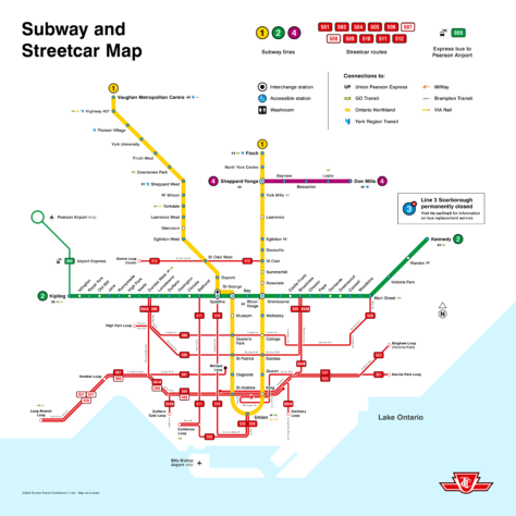
Below we show you the Toronto subway map:

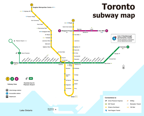
The same Toronto subway map but without the bus lines:

Schedules
- Weekdays and Saturdays: 6:00 AM until 1:30 AM.
- Sundays: 8:00 AM until 1:30 AM.
Rates
- One-way ticket: 3.25 CAD (2.39 USD).
- daily pass: 12.50 CAD.
- Monthly pass: 146.25 CAD.
- Discounts: Available for students, older people and people with disabilities.
Official Web site
- This is the official website of the Toronto subway: Toronto Transit Commission (TTC).
- This is the website with all the attractions and shows in Toronto.
History of the subway
Toronto subway, known as Toronto Transit Commission (TTC), It has an interesting history dating back to the beginning of the 20th century..
Beginnings and first plans
Traffic congestion in Toronto was already a problem in 1910, when the city hired the American traffic consulting firm Jacobs and Davies to study the situation.
In your report, proposed building a subway line along Yonge Street from Union Station to St. Clair Avenue, as well as a two-level viaduct over the Don Valley to accommodate both vehicular and metro traffic..
Crucial progress and decisions
In 1942, Toronto Transit Commission (TTC) began advocating for the development of subway service. With the collaboration of consultant Norman D. Wilson and the De Leuw firm, Cather & Co., The report was prepared “Rapid Transit for Toronto” in 1945. This report recommended major improvements in the speed and comfort of transportation, anticipating the city's explosive growth after World War II.
The 1 January 1946, Toronto citizens overwhelmingly approved the TTC's plan to build the subway in a plebiscite. However, due to post-war supply shortages, The opening ceremony did not take place until 8 September 1949.
Construction of the first subway
Construction of the Yonge subway line began in 1949 and faced several challenges, including steel shortages during the Korean War, which delayed its completion until 1954. The project had a final cost of 67 million dollars.
The first subway train units were purchased from the Gloucester Railway Carriage and Wagon Company in England.. These trains were similar to those used on the London Underground. The first order was placed in November 1951, and the first trains arrived in Toronto in 1953.
Inauguration and expansion
The 30 March 1954, the premier of ontario, Leslie Frost, and the mayor of Toronto, Allan Lamport, Yonge subway line officially opened, the first in Canada, which ran between Union Station and Eglinton Avenue. The ceremony was a significant event, with the presence of dignitaries and a crowd of enthusiastic citizens.
Posteriorly, the system expanded with the Bloor-Danforth line, inaugurated in 1966, and the Sheppard line, open in 2002. Each expansion responded to the growing need for efficient public transportation in a constantly growing city..
Recent and future development
Currently, new lines and extensions are being built, including the Ontario Line and the Eglinton and Finch West light rail lines, scheduled to open (in theory) this same year 2024.
Why is the line closed 3 Toronto subway?
The line 3 Toronto subway, conocida como Scarborough RT, was permanently closed due to maintenance problems and a derailment that occurred in July 2023. The trains on this line were old and difficult to maintain, leading to frequent problems and unreliable operation. After the derailment, which resulted in minor injuries for five people, it was decided to close the line earlier than planned.
To replace this line, A bus service has been implemented that follows the same route and will operate until the extension of the Line 2 of the metro is complete, which is estimated for 2030. There are no plans to reopen the Line 3 as such.
Toronto Subway Map History
The development of the Toronto subway map has evolved significantly since its inception in the 1990s. 1950 to the present, reflecting design changes, system expansion and modernization.
First designs and initial expansion
The original Toronto Subway map was designed for the opening of the Yonge Line in 1954, Canada's first underground line. This initial map was simple, reflecting the uniqueness of the line that ran between Union Station and Eglinton Avenue. At the moment, The design was clear and functional., focused on guiding passengers through the new transportation system.
Changes in materials and aesthetics
In the years 60 y 70, as the subway system expanded with the opening of the Bloor-Danforth line in 1966 and later extensions, the map design also evolved.
During these years, the TTC began employing more durable materials and a more unified aesthetic in its stations and maps, although each station was uniquely designed by different architects, as Arthur Erickson for Eglinton West and Yorkdale, y Dunlop-Farrow Architects para Dupont y Lawrence West (Fuente: Spacing).
Issues with materials and design review
At the end of the years 70 and principles of 80, significant changes were made due to problems with the original materials. The vitrolite tiles used in the first stations began to break and were difficult to replace, prompting the TTC to cover these tiles with wire mesh and install new, more durable tiles in 1982. These changes also affected the layout of the map, that lost some visual cohesion.
Modernization and recovery of the classic style
In 2013, the TTC took steps to preserve its history and redesign its classic typography. TTC design and signage team updated subway typography, known as “Bloor-Yonge”, adding missing numbers and punctuation, and correcting problems with some letters. This modernization effort sought to combine modern functionality with a respect for the system's historic design..
Recent and future expansions
Currently, Toronto's subway system continues to expand with projects like the Ontario Line, the extension of the Eglinton Crosstown line and the Finch West line.
Additional data
The Toronto subway has 52 wheelchair accessible stations; all stations will be accessible to 2025.
Toronto offers cultural and tourist attractions near subway stations, like the CN Tower, the Royal Ontario Museum and Toronto Islands.
The most important tourist places in Toronto are the following:
- CN Tower (Union Station, Yonge-University line): Toronto icon with panoramic views and famous EdgeWalk.
- Royal Ontario Museum (Museum Station, Yonge-University line): Museum with art collections, world-renowned culture and natural history.
- Toronto Islands (Ferry desde Jack Layton Ferry Terminal, near Union Station): Ferry-accessible parks and beaches with stunning views of the skyline.
- Ripley's Aquarium of Canada (Union Station, Yonge-University line): Aquarium with interactive exhibits and a stunning underwater walkway.
- Distillery District (King Station, Yonge-University line): Historic area with shops, restaurants and cultural events in former industrial buildings.
- Casa Loma (Dupont Station, Yonge-University line): Historic castle with gardens, secret tunnels and exhibits.
- Art Gallery of Ontario (St. Patrick Station, Yonge-University line): One of the largest art galleries in North America, with works by Canadian and international artists.
old subway map
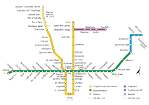
In historical mode, we will hang the old maps here. At the moment we have this one of the year 2014:

