The SkyTrain Vancouver is an underground and elevated transportation system that operates in the city of Vancouver, Canada.
Inaugurated on 3 January 1986, has gone through several expansions, with the last one made in 2016. At the moment, It has three lines that add up to a total of 53 seasons and cover 79.6 kilometres (about 49.46 miles).
Although some call it “Vancouver metro”, actually it is a automated light rail system. It gets its name because most of its infrastructure is elevated, allowing for panoramic views as you travel above the city streets and avenues. Being on elevated roads, looks “float” in the sky. Besides, some sections are also underground, allowing uninterrupted circulation.
SkyTrain Map
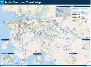
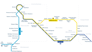
Here's the Vancouver SkyTrain Map in various versions. Click on any image to see it larger.
Vancouver SkyTrain Map with Seabus:
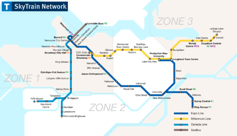
We also have the previous map of the Vancouver SkyTrain map with Seabus in PDF format.
Vancouver SkyTrain Map:
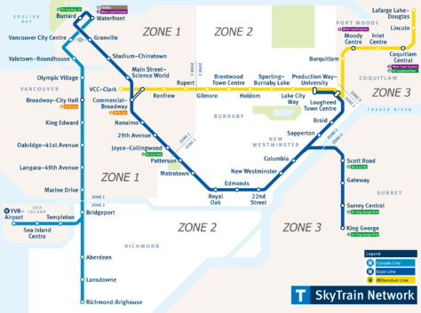
The previous map of Vancouver SkyTrain map in PDF format.
Vancouver SkyTrain Map, with RapidBus lines, SeaBus, West Coast Express:
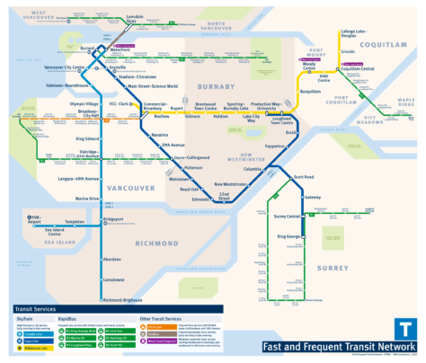
Here is the previous map of the Vancouver SkyTrain Map, with RapidBus lines, SeaBus, West Coast Express en formato PDF.
Vancouver SkyTrain Map, with bus lines, RapidBus, SeaBus y West Coast Express:
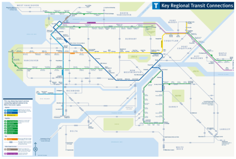
We have the previous map of the Vancouver SkyTrain Map, with bus lines, RapidBus, SeaBus and West Coast Express in PDF format.
Official Web site
- For more information, visit the Vancouver SkyTrain Official Site.
- Web with the complete list of all tourist attractions in Vancouver.
- Web with the official SkyLine interactive map.
SkyTrain Schedule
The Vancouver SkyTrain operates with the following schedules:
- Work days: of 5:00h until 1:00h.
- Saturdays: of 5:00h until 1:00h of the next day.
- Sundays and holidays: of 6:00h until 0:00h.
Rates
Here's a summary of SkyTrain fares in Vancouver, including top pricing and discount options available with the Compass Card, in canadian dollars (CAD) and its approximate equivalent in US dollars (USD, to the approximate current change of 1 CAD = 0.74 USD):
| Ticket Type | 1 Zone | 2 Zones | 3 Zones |
|---|---|---|---|
| Adult (cash) | $3.15 (USD 2.33) | $4.55 (USD 3.37) | $6.20 (USD 4.59) |
| concession (cash) | $2.10 (USD 1.55) | $3.10 (USD 2.29) | $4.25 (USD 3.15) |
| Adult (Compass Card) | $2.55 (USD 1.89) | $3.75 (USD 2.78) | $4.80 (USD 3.55) |
| concession (Compass Card) | $2.10 (USD 1.55) | $3.10 (USD 2.29) | $4.25 (USD 3.15) |
| Daily Pass (Adult) | *Applies to all areas | $11.25 (USD 8.33) | *Applies to all areas |
| Daily Pass (concession) | *Applies to all areas | $8.85 (USD 6.55) | *Applies to all areas |
Use: Concessional rates apply to people over 65 years, young people of 13 a 18 years and people with identifiable disabilities. Children under 12 years travel free.
Special rates
- AddFare From the airport: There is a surcharge of $5.00 for travel to or from Vancouver International Airport (YVR) regardless of the area.
- Trips after 6:30 p.m. during weekdays and weekends, or holidays, are charged as a fee 1 zone, regardless of the number of zones crossed.
Card Options Compass From the airport
The card Compass is the most convenient payment method for traveling on the SkyTrain. These cards can be loaded with stored value or monthly passes can be purchased:
| Pass Type Compass | 1 Zone | 2 Zones | 3 Zones |
|---|---|---|---|
| Monthly pass (Adult) | $104.90 (USD 77.63) | $140.25 (USD 103.79) | $189.45 (USD 140.20) |
| Monthly pass (concession) | *Not available | *Not available | $59.95 (USD 44.36) |
These cards can also be purchased at vending machines located at the stations., facilitating access for residents and tourists.
History of the Vancouver SkyTrain
The Vancouver SkyTrain, a crucial initiative for the city's transportation infrastructure, began to take shape in the decade of 1980 as part of preparations for the Expo 86. The first segment of the Expo Line was inaugurated in 1986, marking the beginning of service between the stations Waterfront y New Westminster.
In 1989 y 1990, the Expo Line spread beyond New Westminster until you reach King George Station in Surrey in 1994, making this line a vital artery for transportation in the region.
The next major development was Millennium Line, inaugurated in the year 2002. This line was extended in several phases, with the last big expansion, the Evergreen Extension, opening in 2016 to connect more communities in the area Tri-Cities.
The Canada Line was inaugurated in 2009 just before the Winter Olympics 2010. Unlike the other lines, was developed through a public-private partnership and led by InTransitBC, including the engineering firm SNC-Lavalin. This line connects downtown Vancouver with the international airport and Richmond, transforming traffic in the southern corridor of the city.
Recent projects include the Broadway Extension of the Millennium Line, currently under construction and scheduled to open in 2026. This extension aims to further improve accessibility in one of the city's busiest corridors..
History of the SkyTrain map
Since its beginnings in 1986, The map has gone through various transformations, guided by the collaboration of numerous professionals and companies.
The Vancouver SkyTrain concept materialized with the Expo 86, with the Expo Line as its first manifestation. Ken Sutherland, an influential designer, was crucial in the early designs of the SkyTrain map and stations, ensuring both functionality and aesthetics. The Urban Transportation Development Corporation (UTDC), based in Ontario, He was in charge of the first designs and construction of the wagons Mark 1.
The SkyTrain map was expanded with the introduction of the Millennium Line in 2002 and the Canada Line in 2009. The Millennium Line was designed to serve the growing eastern suburbs, while the Canada Line, a collaboration with InTransitBC (which includes SNC-Lavalin), connects Vancouver with Richmond and the international airport. This line was established as a public-private partnership, one of the largest in Canadian history.
The latest version of the map is 2016, showing the station Lafarge Lake–Douglas. This station is part of the extension Evergreen of the Millennium Line, and it opened 2 December 2016.
Additional data
Vancouver's SkyTrain is not only an efficient transportation system, but also a gateway to some of the city's most impressive attractions:
- Stanley Park (Season Burrard): This station connects visitors to the iconic park that features scenic trails and a unique mix of nature and cultural activities..
- Granville Island (Season Yaletown-Roundhouse): A short distance from this station is the bustling market and arts center, offering a unique culinary and cultural experience.
- Anthropology Museum (Season UBC Loop, bus access): Although it is not directly connected to the SkyTrain, The museum can be accessed via buses from the nearest station, highlighting the rich cultural heritage of the indigenous peoples of the region.
- Gastown (Season Waterfront): The station serves as a portal to one of Vancouver's oldest historic neighborhoods, famous for its steam clock and modern boutiques.
Old Skymap maps
In historical mode, we are hanging the old maps. These are from the year 2014:

