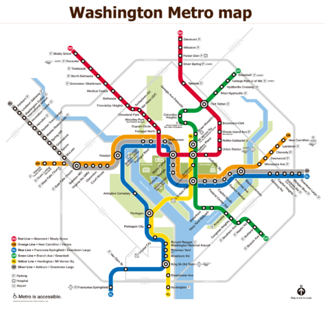
The Washington Metro, officially known as Metrorail, is the rapid transit system serving the Washington metropolitan area, DC., city located in the United States.
Administered by the Washington Metropolitan Area Transit Authority (WMATA), the metro was inaugurated in 1976 and has expanded to include six color lines (Red, Blue, Orange, Yellow, Green & Silver), with a total of 98 stations and 129 miles (208 km) of roads. The system covers the District of Columbia and extends to the suburbs of Maryland and Virginia.
Here's the washington dc metro map, Click image to enlarge:

If you wish, there is a version of it Washington metro map in PDF version.
Washington Metro Schedules
The Washington Metro operating hours are as follows:
- Monday to thursday: 5:00 a.m. – 12:00 a.m.
- Friday: 5:00 a.m. – 1:00 a.m.
- Saturday: 7:00 a.m. – 1:00 a.m.
- Sunday: 7:00 a.m. – 12:00 a.m.
Rates
The cost of tickets on the Washington metro varies depending on the distance traveled, the time of day and type of card used. Fees can range from $2.00 y $6.00 in local currency. Users can use the SmarTrip card, a reloadable card that is also available in digital version for Apple and Google Wallet.
Official Web site
- This is the official website of the Washington Metro.
- This is the website with all the shows and attractions in Washington, and online ticket purchase.
History of the subway

The history of the Washington subway, DC, it is a testament to twentieth-century urban planning and engineering. Here is the chronology of its development and expansion:
Origins and initial planning
The idea of a subway system in Washington began to take shape in the 1990s. 1950. During this time, the Planning Commission of the National Capital (NCPC) developed a master plan that included the creation of a rapid transit network to complement the highway infrastructure projected for the region. In 1960, the federal government created the National Capital Transportation Agency (NCTA) To study and plan the subway system.
In 1967, WMATA was established through an interstate agreement between Washington and the United States., DC, Maryland and Virginia, with the aim of designing, Build and operate the subway system. Construction began in December 1969.
Construction and opening phases
- Phase 1 (1969-1976):
- The first line to open was the Red Line, with the first leg between Farragut North and Rhode Island Avenue opened on 27 March 1976. This initial segment included five stations.
- Phase 2 (1977-1980):
- In 1977, the Red Line was extended to Silver Spring and the Blue Line was opened between National Airport (now Ronald Reagan Washington National Airport) and Stadium-Armory. The Orange Line also began operations in 1978 between New Carrollton and Ballston.
- Phase 3 (1980-1991):
- This phase saw the opening of the Yellow Line in 1983 and the Green Line in 1991. The Yellow Line connected Huntington to Gallery Place, and the Green Line initially extended from U Street to Anacostia.
- Phase 4 (1991-2004):
- The decade of 1990 and principles of 2000 focused on the extension of existing lines. The Green Line was completed in 2001, stretching from Greenbelt in Maryland to Branch Avenue.
Recent expansions
- Silver Line (2014-2023):
- One of the most significant expansions was the inauguration of the Silver Line. The first phase opened in 2014, stretching from East Falls Church to Wiehle-Reston East. The Second Phase, completed in 2022, extended the line to Ashburn in Loudoun County, including a station at Dulles International Airport.
- The Newest Station, Potomac Yard, The 19 May 2023, improving access to new areas of development in Virginia.
Construction Challenges and Techniques
The construction of the Washington Subway involved several challenges, especially due to the need to excavate in densely populated areas and with historic buildings. Most of the stations were built using the “cut and cover“, That involves digging a trench, cover it and then rebuild the surface. However, in areas where the terrain was rocky, as Dupont Circle, Woodley Park and Cleveland Park, Drill and blast techniques were used.
History of the Washington Metro Map, DC
Washington metro map, DC, has evolved significantly since its inception in 1976, becoming an icon of both urban design and transport cartography.
First designs and developments
The original design of the map was created by Lance Wyman, a prominent American graphic designer known for his work on the visual identity of the Mexico Olympics 1968. Wyman was hired by the Washington Metropolitan Area Transit Authority (WMATA) to develop a map that would be intuitive and easy to use for subway users.
Wyman's approach focused on clarity and simplicity, using brightly colored lines and clearly marked seasons. This design helped users navigate the system efficiently, despite the complexities of Washington's underground cityscape. Colored Lines, one for each subway route, and the circles for the stations became the basis of the design that has been maintained over the decades.
Updates and changes
Over the years, The map has been updated several times to reflect system expansions and improve readability. In 2012, For example, The “Rush+ System Map” to accommodate the new rush hour service. This version of the map incorporated new symbologies and tweaks to the design to improve the geographic accuracy of lines and stations.
The most recent changes included the addition of the Silver Line, which was one of the most significant expansions. The map layout has also been adjusted to include subtitles on stations with long names, thus improving the readability and overall aesthetics of the map.
Challenges and solutions in design
One of the main challenges in map design has been balancing geographic accuracy with visual clarity. Although the Washington metro map is stylized in a schematic format similar to the famous london tube map de Harry Beck, Continuous efforts have been made to correct geographical distortions and improve the user experience. For example, The locations of some stations have been adjusted to better reflect their actual relative position and additional symbols have been introduced to indicate specific services and transfers.
Collaborations and competencies
On several occasions, WMATA has engaged the community in the map redesign process through contests and surveys. These efforts have resulted in a wide range of feedback and suggestions that have contributed to continuous improvements to the map's design. Community engagement has been instrumental in ensuring that the map is not only functional, but also well received by its users.
Additional data
- Escalators: Wheaton Station on the Red Line features the longest escalator in the Western Hemisphere, con 230 pies (70 m) Length.
- Turismo: The subway makes it easy to access many tourist attractions in Washington, DC, including the Smithsonian (Orange Lines, Silver & Blue), the National Zoo (Red Line) and the National Mall.
- Connectivity: The Silver Line connects directly to Dulles International Airport, while the Blue and Yellow Lines serve Ronald Reagan National Airport.
The most touristic sites in Washington are as follows:
- National Mall (Smithsonian, Orange Lines, Silver & Blue): Sprawling green space with iconic landmarks and free Smithsonian museums.
- U.S. Capitol (Capitol South, Orange Line, Silver & Blue): U.S. Congress Headquarters. U.S., Offers free guided tours.
- White House (McPherson Square, Orange Line, Silver & Blue): Official Residence of the President of the United States, Accessible with prior tour.
- National Museum of Natural History (Smithsonian, Orange Lines, Silver & Blue): Smithsonian Museum with Fossils, Gems & Natural History Exhibits.
- Lincoln Memorial (Foggy Bottom, Orange Line, Silver & Blue): Iconic monument dedicated to President Abraham Lincoln, located on the National Mall.
- National Air and Space Museum (L'Enfant Plaza, Green Lines, Yellow, Orange, Silver & Blue): Smithsonian Museum with aviation and space exploration exhibits.
- Washington Monument (Smithsonian, Orange Lines, Silver & Blue): Obelisk Honoring George Washington, It offers panoramic views of the city.