Yokohama Municipal Subway (officially called 横浜市営地下鉄) operates in the city of Yokohama, Japan.
Inaugurated on 12 December 1972, has 3 lines that add up to a total of 42 stations. Its length reaches 53.4 km (33.2 miles). The Blue Line was the first to open, followed by the Green Line and the Red Line. These lines expanded in phases, the last in 2008.
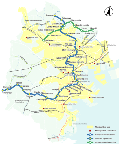
subway map
Below we show you the Yokohama subway map:

If you wish you can download the Yokohama subway map in PDF format.
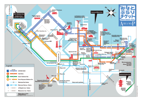
Below is the transportation map and points of interest of Yokohama:

We also have it in formato PDF.
Yokohama Subway Schedule
Every day: 5:00 a 0:00.
Metro fares
Yokohama Subway offers a variety of fares. Next, A table is shown with the main rates in Japanese yen (JPY), and its equivalent in US dollars (USD), so that tourists have a better idea of the price:
| Type of ticket | Precio (JPY) | Precio (USD) |
|---|---|---|
| One-way ticket (1-6 km) | 210 JPY | 1.54 USD |
| One-way ticket (7-12 km) | 260 JPY | 1.91 USD |
| One-way ticket (13-18 km) | 310 JPY | 2.28 USD |
| One-way ticket (19-24 km) | 360 JPY | 2.65 USD |
| One-way ticket (25-30 km) | 410 JPY | 3.02 USD |
Special cards and passes
1. PASMO y Suica: They are rechargeable cards used on public transportation throughout the Tokyo metropolitan area., including Yokohama. These cards offer the convenience of not having to buy individual tickets for each trip.
2. 1-Day Pass: Allows unlimited trips on the subway for one day per 740 JPY (5.42 USD). It is ideal for tourists who want to explore the city.
3. Minato Burari Ticket: Offers unlimited rides on the Yokohama subway and sightseeing bus for one day. The cost is 500 JPY (3.66 USD) for adults and 250 JPY (1.83 USD) for children.
4. Hama Wing Eco Card: It is a discount card for seniors and disabled people that offers reduced fares on the subway and other transportation services in Yokohama.
Official Web site
- Official website of the metro de Yokohama.
History of the Yokohama Subway

Yokohama subway inaugurated its first line, the blue line (line 1), he 12 December 1972. This initial section connected the Kami-Ōoka and Isezaki-Chōjamachi stations. The expansion of this line continued in stages, reaching Shōnandai in 1999, which consolidated a total length of 40.4 km.
In 1985, the Green Line (line 3) opened its first section between Hiyoshi and Nakayama. This line was extended in several phases until reaching Azamino in 1993, and its total length is 13 km.
The third line, known as Red Line (line 2), connects Yokohama Station with Azamino and was completed in 2008. This line is crucial for the link between the city center and suburban areas.
The design and construction of the subway involved several prominent Japanese engineering and construction companies., as Mitsubishi Heavy Industries y Obayashi Corporation. Japanese and foreign engineers collaborated to develop an efficient and safe system, adapted to the specific needs of the city.
Yokohama Subway Map History
Initially in 1972, The design of the map was commissioned by the Yokohama City Transportation Office.. Local engineers and designers worked to create a clear and functional map for users. On the first years, the map was centered on the existing lines, the Blue Line and the Green Line, with a simple and direct design.
As the subway expanded, the need for a more sophisticated design became evident. In the years 80, the cartographic map design company, Zenrin, collaborated with the Office of Transportation to update the map. Zenrin contributed his experience in cartography, improving map readability and accuracy.
In the decade of 2000, with the opening of new stations and the integration of additional transport systems, the map design was revised again. This time, Japanese graphic designer Eiji Mitooka, known for his work on train and station designs, contributed to modernizing the metro map, integrating distinctive colors and a more intuitive design for passengers.
The last significant update to the Yokohama subway map occurred in 2015, when the design company GK Industrial Design, famous for her work on transportation projects in Japan, was hired to redesign the subway map. This redesign included greater clarity in connections and transfers, as well as the incorporation of universal symbols to facilitate navigation for tourists and international users.
Additional data
Yokohama is known for its port, one of the most important in Japan, and for being a center of technological innovation. The subway facilitates access to tourist sites such as Yokohama's Chinatown, the largest in Japan, and the famous viewpoint Landmark Tower. Besides, connects with the area of Minato Mirai 21, a modern urban district with shopping centers, museums and entertainment areas.
Below is the list of the most visited tourist places in Yokohama, and its nearest metro stops:
- Minato Mirai 21 (Minato Mirai, Minato Mirai Line): A modern urban district with skyscrapers, malls, y el Landmark Tower, the second tallest building in Japan.
- Yokohama Chinatown (Motomachi-Chukagai, Minato Mirai Line): The largest Chinatown in Japan, famous for its food and cultural festivities.
- Sankei-en Garden (Negishi, Línea Keihin-Tohoku): A traditional Japanese garden with ponds, historic bridges and buildings brought from all over Japan.
- Yokohama Red Brick Warehouse (Bashamichi, Minato Mirai Line): Former warehouses converted into a cultural center with shops, restaurants and artistic events.
- Cup Noodles Museum (Minato Mirai, Minato Mirai Line): An interactive museum where visitors can learn about the history of instant ramen and create their own noodles.
- Yamashita Park (Motomachi-Chukagai, Minato Mirai Line): A seaside park with beautiful views of the harbor and the Hikawa Maru, an old ocean liner converted into a museum.
- Yokohama Cosmo World (Minato Mirai, Minato Mirai Line): An amusement park with the iconic Cosmo Clock Ferris wheel 21, offering panoramic views of the city.
- Osanbashi Pier (Nihon-odori, Minato Mirai Line): A cruise ship dock with an observation deck and gardens providing stunning views of the harbor and city.